
Faire un don
Équipez-vous pour votre prochaine aventure :
En tant que Partenaire Amazon, ce site perçoit une commission sur les achats éligibles sans surcoût pour vous.
Carte topographique Shkhara
Cliquez sur la carte pour afficher l’altitude.
Faire un don
Équipez-vous pour votre prochaine aventure :
En tant que Partenaire Amazon, ce site perçoit une commission sur les achats éligibles sans surcoût pour vous.
À propos de cette carte
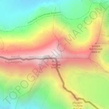
Nom : Carte topographique Shkhara, altitude, relief.
Altitude moyenne : 4 355 m
Altitude minimum : 3 504 m
Altitude maximum : 5 224 m
Faire un don
Équipez-vous pour votre prochaine aventure :
En tant que Partenaire Amazon, ce site perçoit une commission sur les achats éligibles sans surcoût pour vous.
Autres cartes topographiques
Cliquez sur une carte pour visualiser sa topographie, son altitude et son relief.
Central Caucasian Ridge
Russia > Kabardino-Balkaria > Cherek District > Verkhnyaya Balkariya
The highest and rockiest section of the range is located in its central part. Although not as high as the topmost summits of the Lateral Range to the north, the highest elevations of the Main Caucasian Range include the 5,193 meters (17,037 ft) high Shkhara, the 4,466 meters (14,652 ft) high Mount Bazardüzü…
Altitude moyenne : 2 784 m