
Faire un don
Équipez-vous pour votre prochaine aventure :
En tant que Partenaire Amazon, ce site perçoit une commission sur les achats éligibles sans surcoût pour vous.
Carte topographique Lancaster
Cliquez sur la carte pour afficher l’altitude.
Faire un don
Équipez-vous pour votre prochaine aventure :
En tant que Partenaire Amazon, ce site perçoit une commission sur les achats éligibles sans surcoût pour vous.
Lancaster
Just south of the village center is Mount Prospect, summer home to Senator John W. Weeks, who sponsored congressional legislation creating White Mountain National Forest. In 1910, he purchased several farms to assemble the 420-acre (170 ha) estate. It is now Weeks State Park, which features a fire lookout and his mansion, open for tours during the summer. The Mount Prospect Ski Tow operates on the slope in winter, snow conditions permitting. Many of the White Mountains and Green Mountains can be seen from the stone observation tower built in 1912 atop the 2,059-foot (628 m) summit. The Presidential Range is to the southeast, with the Franconia Range to the south. Mount Weeks, elevation 3,900 ft (1,200 m), is in the Kilkenny Range to the northeast. It is named for the senator, as is the Weeks Medical Center. Weeks Memorial Library, a Beaux Arts landmark listed on the National Register of Historic Places in 2000, was given by John W. Weeks in memory of his father, William Dennis Weeks.
Faire un don
Équipez-vous pour votre prochaine aventure :
En tant que Partenaire Amazon, ce site perçoit une commission sur les achats éligibles sans surcoût pour vous.
À propos de cette carte
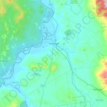
Nom : Carte topographique Lancaster, altitude, relief.
Lieu : Lancaster, Coös County, New Hampshire, 03584, United States (44.41019 -71.66063 44.53864 -71.42977)
Altitude moyenne : 372 m
Altitude minimum : 248 m
Altitude maximum : 1 113 m
Faire un don
Équipez-vous pour votre prochaine aventure :
En tant que Partenaire Amazon, ce site perçoit une commission sur les achats éligibles sans surcoût pour vous.
Autres cartes topographiques
Cliquez sur une carte pour visualiser sa topographie, son altitude et son relief.
Mount Washington
United States > New Hampshire > Coos County
Mount Washington, in New Hampshire, is the highest peak in the Northeastern United States at 6,288.2 ft (1,916.6 m) and the most topographically prominent mountain east of the Mississippi River.
Altitude moyenne : 1 568 m
Mount Adams
United States > New Hampshire > Coos County
Mount Adams, elevation 5,793 feet (1,766 m) above sea level, is a mountain in New Hampshire, the second highest peak in the Northeast United States after its nearby neighbor, Mount Washington. Located in the northern Presidential Range, Mount Adams was named after John Adams, the second President of the United…
Altitude moyenne : 1 379 m
Faire un don
Équipez-vous pour votre prochaine aventure :
En tant que Partenaire Amazon, ce site perçoit une commission sur les achats éligibles sans surcoût pour vous.
Mount Washington
United States > New Hampshire > Coos County
Mount Washington, also known as Agiocochook, is an ultra-prominent mountain in the state of New Hampshire. It is the highest peak in the Northeastern United States at 6,288.2 ft (1,916.6 m) and the most topographically prominent mountain east of the Mississippi River.
Altitude moyenne : 1 568 m
Mount Washington
United States > New Hampshire > Coos County
Mount Washington is an ultra-prominent mountain in the state of New Hampshire. It is the highest peak in the Northeastern United States at 6,288.2 ft (1,916.6 m) and the most topographically prominent mountain east of the Mississippi River.
Altitude moyenne : 1 568 m
Mount Washington
United States > New Hampshire > Coos County
Mount Washington, also known as Agiocochook, is an ultra-prominent mountain in the state of New Hampshire. It is the highest peak in the Northeastern United States at 6,288.2 ft (1,916.6 m) and the most topographically prominent mountain east of the Mississippi River.
Altitude moyenne : 1 568 m
Faire un don
Équipez-vous pour votre prochaine aventure :
En tant que Partenaire Amazon, ce site perçoit une commission sur les achats éligibles sans surcoût pour vous.
Faire un don
Équipez-vous pour votre prochaine aventure :
En tant que Partenaire Amazon, ce site perçoit une commission sur les achats éligibles sans surcoût pour vous.
Faire un don
Équipez-vous pour votre prochaine aventure :
En tant que Partenaire Amazon, ce site perçoit une commission sur les achats éligibles sans surcoût pour vous.
Faire un don
Équipez-vous pour votre prochaine aventure :
En tant que Partenaire Amazon, ce site perçoit une commission sur les achats éligibles sans surcoût pour vous.