
Carte topographique Wolf
Carte interactive
Cliquez sur la carte pour afficher l’altitude.
À propos de cette carte
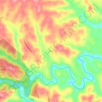
Nom : Carte topographique Wolf, altitude, relief.
Lieu : Wolf, Carter County, Kentucky, United States (38.35925 -83.11934 38.39925 -83.07934)
Altitude moyenne : 271 m
Altitude minimum : 205 m
Altitude maximum : 325 m
Autres cartes topographiques
Cliquez sur une carte pour visualiser sa topographie, son altitude et son relief.
Grayson
United States > Kentucky > Carter County
Grayson, Carter County, Kentucky, United States
Altitude moyenne : 208 m
Denton
United States > Kentucky > Carter County
Denton, Carter County, Kentucky, 41132, United States
Altitude moyenne : 232 m
Hitchins
United States > Kentucky > Carter County
Hitchins, Carter County, Kentucky, 41146, United States
Altitude moyenne : 215 m
Grahn
United States > Kentucky > Carter County
Grahn, Carter County, Kentucky, 41142, United States
Altitude moyenne : 266 m
Olive Hill
United States > Kentucky > Carter County
Olive Hill, Carter County, Kentucky, 41164, United States
Altitude moyenne : 274 m