
Carte topographique Florissant Fossil Beds National Monument
Carte interactive
Cliquez sur la carte pour afficher l’altitude.
À propos de cette carte
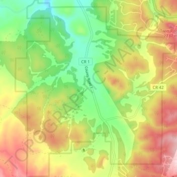
Nom : Carte topographique Florissant Fossil Beds National Monument, altitude, relief.
Altitude moyenne : 2 616 m
Altitude minimum : 2 494 m
Altitude maximum : 2 757 m
Early estimates of the elevation of the Florissant beds was determined to be between 300–900 meters, much lower than the modern elevation of 2,500-2,600 meters. However, more recent estimates that are based on paleoflora have put the elevation in the Eocene much higher. Ranges from 1,900 to 4,100 meters have been proposed. This would indicate that global climate change, rather than tectonic uplift, would be the main cause of changing environments in the area. The actual elevation of the Florissant area during the Eocene is still being determined. While most of the analysis using paleoflora has the area at a higher elevation than modern times, there is evidence that the elevation was as low as the earlier estimates.
Autres cartes topographiques
Cliquez sur une carte pour visualiser sa topographie, son altitude et son relief.
Florissant
United States > Colorado > Teller County
Florissant, Teller County, Colorado, United States
Altitude moyenne : 2 556 m
Divide
United States > Colorado > Teller County
Divide, Teller County, Colorado, United States
Altitude moyenne : 2 796 m
Cripple Creek
United States > Colorado > Teller County
Cripple Creek, Teller County, Colorado, United States
Altitude moyenne : 2 946 m
Woodland Park
United States > Colorado > Teller County
Woodland Park, Teller County, Colorado, 80863, United States
Altitude moyenne : 2 652 m