
Carte topographique Tring
Cliquez sur la carte pour afficher l’altitude.
À propos de cette carte
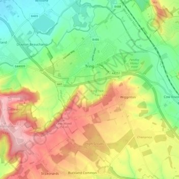
Nom : Carte topographique Tring, altitude, relief.
Lieu : Tring, Dacorum, Hertfordshire, England, United Kingdom (51.75304 -0.69022 51.81803 -0.62378)
Altitude moyenne : 168 m
Altitude minimum : 87 m
Altitude maximum : 270 m
Autres cartes topographiques
Cliquez sur une carte pour visualiser sa topographie, son altitude et son relief.
Long Marston
United Kingdom > England > Hertfordshire > Dacorum > Long Marston
Altitude moyenne : 92 m
Saint Margarets Copse
United Kingdom > England > Hertfordshire > Dacorum > Great Gaddesden
Altitude moyenne : 144 m
Hammerfield
United Kingdom > England > Hertfordshire > Dacorum > Hemel Hempstead
Altitude moyenne : 122 m
Tringford Reservoir
United Kingdom > England > Hertfordshire > Dacorum > Tring > Wilstone
Altitude moyenne : 119 m
Dixon's Gap Bridge
United Kingdom > England > Hertfordshire > Dacorum > Wilstone > Gubblecote
Altitude moyenne : 101 m
Westbrook Mere
United Kingdom > England > Hertfordshire > Dacorum > Bourne End
Altitude moyenne : 125 m
Trowley Bottom
United Kingdom > England > Hertfordshire > Dacorum > Flamstead
Altitude moyenne : 139 m
Nettleden
United Kingdom > England > Hertfordshire > Dacorum > Great Gaddesden
Altitude moyenne : 149 m
Bovingdon Green
United Kingdom > England > Hertfordshire > Dacorum > Bovingdon
Altitude moyenne : 151 m
Frithsden Beeches
United Kingdom > England > Hertfordshire > Dacorum > Potten End
Altitude moyenne : 160 m