
Faire un don
Équipez-vous pour votre prochaine aventure :
En tant que Partenaire Amazon, ce site perçoit une commission sur les achats éligibles sans surcoût pour vous.
Carte topographique Docking
Cliquez sur la carte pour afficher l’altitude.
Faire un don
Équipez-vous pour votre prochaine aventure :
En tant que Partenaire Amazon, ce site perçoit une commission sur les achats éligibles sans surcoût pour vous.
Docking
Docking village in the centre of the parish is situated at an elevation of 82.7 metres (272 feet), which makes it one of the highest in Norfolk. It is surrounded by arable farmland having little woodland and is a nucleated settlement, with only one historical hamlet associated with it. This is Summerfield to the north-west, the site of a separate medieval village. The two modern hamlets in the parish are Burntstalk to the west around the former workhouse, and Docking Common to the south-east which postdates the enclosure of the village common in 1859.
Faire un don
Équipez-vous pour votre prochaine aventure :
En tant que Partenaire Amazon, ce site perçoit une commission sur les achats éligibles sans surcoût pour vous.
À propos de cette carte
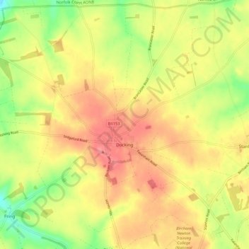
Nom : Carte topographique Docking, altitude, relief.
Altitude moyenne : 63 m
Altitude minimum : 20 m
Altitude maximum : 94 m
Faire un don
Équipez-vous pour votre prochaine aventure :
En tant que Partenaire Amazon, ce site perçoit une commission sur les achats éligibles sans surcoût pour vous.
Autres cartes topographiques
Cliquez sur une carte pour visualiser sa topographie, son altitude et son relief.
St John's Fen End
United Kingdom > England > Norfolk > King's Lynn and West Norfolk
Altitude moyenne : 1 m
Brandon Bank
United Kingdom > England > Norfolk > King's Lynn and West Norfolk > Feltwell
Altitude moyenne : -1 m
Faire un don
Équipez-vous pour votre prochaine aventure :
En tant que Partenaire Amazon, ce site perçoit une commission sur les achats éligibles sans surcoût pour vous.
Faire un don
Équipez-vous pour votre prochaine aventure :
En tant que Partenaire Amazon, ce site perçoit une commission sur les achats éligibles sans surcoût pour vous.
Great Bircham
United Kingdom > England > Norfolk > King's Lynn and West Norfolk
Altitude moyenne : 61 m
Bircham Tofts
United Kingdom > England > Norfolk > King's Lynn and West Norfolk > Great Bircham
Altitude moyenne : 63 m
Brancaster Staithe
United Kingdom > England > Norfolk > King's Lynn and West Norfolk
Altitude moyenne : 18 m
Faire un don
Équipez-vous pour votre prochaine aventure :
En tant que Partenaire Amazon, ce site perçoit une commission sur les achats éligibles sans surcoût pour vous.
Methwold Hythe
United Kingdom > England > Norfolk > King's Lynn and West Norfolk > Methwold
Altitude moyenne : 8 m
Flaxley
United Kingdom > England > Norfolk > King's Lynn and West Norfolk > Holme next the Sea
Altitude moyenne : 8 m
Old Hunstanton Lighthouse
United Kingdom > England > Norfolk > King's Lynn and West Norfolk > Hunstanton > Old Hunstanton
Altitude moyenne : 9 m
Faire un don
Équipez-vous pour votre prochaine aventure :
En tant que Partenaire Amazon, ce site perçoit une commission sur les achats éligibles sans surcoût pour vous.
Walpole St Andrew
United Kingdom > England > Norfolk > King's Lynn and West Norfolk
Altitude moyenne : 3 m
Ely-Ouse-Essex Water Transfer Scheme
United Kingdom > England > Norfolk > King's Lynn and West Norfolk > Hockwold cum Wilton
Altitude moyenne : 4 m
St John's Highway
United Kingdom > England > Norfolk > King's Lynn and West Norfolk
Altitude moyenne : 2 m
Sandringham Estate
United Kingdom > England > Norfolk > King's Lynn and West Norfolk > Sandringham
Altitude moyenne : 25 m
Faire un don
Équipez-vous pour votre prochaine aventure :
En tant que Partenaire Amazon, ce site perçoit une commission sur les achats éligibles sans surcoût pour vous.
Walton Highway
United Kingdom > England > Norfolk > King's Lynn and West Norfolk
Altitude moyenne : 3 m
Denver Sluice
United Kingdom > England > Norfolk > King's Lynn and West Norfolk > Downham Market
Altitude moyenne : 2 m
Marshland St James
United Kingdom > England > Norfolk > King's Lynn and West Norfolk
Altitude moyenne : 1 m
Faire un don
Équipez-vous pour votre prochaine aventure :
En tant que Partenaire Amazon, ce site perçoit une commission sur les achats éligibles sans surcoût pour vous.
Pott Row
United Kingdom > England > Norfolk > King's Lynn and West Norfolk > Pott Row
Altitude moyenne : 18 m
Saint Hilary Park
United Kingdom > England > Norfolk > King's Lynn and West Norfolk > King's Lynn
Altitude moyenne : 7 m
Castle Rising
United Kingdom > England > Norfolk > King's Lynn and West Norfolk > Castle Rising
Altitude moyenne : 22 m
Faire un don
Équipez-vous pour votre prochaine aventure :
En tant que Partenaire Amazon, ce site perçoit une commission sur les achats éligibles sans surcoût pour vous.
Pur Fleet
United Kingdom > England > Norfolk > King's Lynn and West Norfolk > King's Lynn
Altitude moyenne : 5 m
Suspension Bridge
United Kingdom > England > Norfolk > King's Lynn and West Norfolk > Welney > Suspension Bridge
Altitude moyenne : 1 m
Old Bedford River
United Kingdom > England > Norfolk > King's Lynn and West Norfolk
Altitude moyenne : 1 m
Faire un don
Équipez-vous pour votre prochaine aventure :
En tant que Partenaire Amazon, ce site perçoit une commission sur les achats éligibles sans surcoût pour vous.