
Faire un don
Équipez-vous pour votre prochaine aventure :
En tant que Partenaire Amazon, ce site perçoit une commission sur les achats éligibles sans surcoût pour vous.
Carte topographique Wallenthal
Cliquez sur la carte pour afficher l’altitude.
Faire un don
Équipez-vous pour votre prochaine aventure :
En tant que Partenaire Amazon, ce site perçoit une commission sur les achats éligibles sans surcoût pour vous.
Wallenthal
Der Ort liegt zwischen Voißel, Stadtteil von Mechernich, und Scheven. Am Ortsrand verlaufen die Kreisstraße 27 und die Bundesstraße 266, die von Mechernich nach Gemünd führt. Durch den Ort führt der Radfernweg Eifel-Höhen-Route, der als Rundkurs um und durch den Nationalpark Eifel verläuft.
Faire un don
Équipez-vous pour votre prochaine aventure :
En tant que Partenaire Amazon, ce site perçoit une commission sur les achats éligibles sans surcoût pour vous.
À propos de cette carte
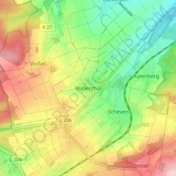
Nom : Carte topographique Wallenthal, altitude, relief.
Altitude moyenne : 389 m
Altitude minimum : 302 m
Altitude maximum : 491 m
Faire un don
Équipez-vous pour votre prochaine aventure :
En tant que Partenaire Amazon, ce site perçoit une commission sur les achats éligibles sans surcoût pour vous.
Autres cartes topographiques
Cliquez sur une carte pour visualiser sa topographie, son altitude et son relief.
Sistiger Heide
Deutschland > Nordrhein-Westfalen > Kreis Euskirchen > Kall > Benenberg
Altitude moyenne : 570 m