
Carte topographique Sonamarg
Carte interactive
Cliquez sur la carte pour afficher l’altitude.
À propos de cette carte
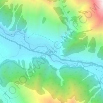
Nom : Carte topographique Sonamarg, altitude, relief.
Lieu : Sonamarg, Kangan, Ganderbal district, Jammu and Kashmir, India (34.28239 75.27656 34.32239 75.31656)
Altitude moyenne : 3 068 m
Altitude minimum : 2 639 m
Altitude maximum : 4 240 m
The hill station is situated in the Kashmir Valley, at an altitude of 2,730 metres (8,960 ft) and is close to some of the valley's tallest peaks, alongside the Machoi Glacier, Sirbal Peak, Kolahoi Peak, Amarnath Peak and Machoi Peak. Combined with the alpine meadows that bloom in the summer as well as rivers and lakes stocked with fish, Sonamarg is a notable tourist destination in Jammu and Kashmir.
Autres cartes topographiques
Cliquez sur une carte pour visualiser sa topographie, son altitude et son relief.
Gagangir
India > Jammu and Kashmir > Kangan
Gagangir, Kangan, Ganderbal district, Jammu and Kashmir, India
Altitude moyenne : 2 795 m
Kangan
India > Jammu and Kashmir > Kangan
Kangan, Ganderbal District, Jammu and Kashmir, India
Altitude moyenne : 3 335 m