
Faire un don
Équipez-vous pour votre prochaine aventure :
En tant que Partenaire Amazon, ce site perçoit une commission sur les achats éligibles sans surcoût pour vous.
Carte topographique East Lyme
Cliquez sur la carte pour afficher l’altitude.
Faire un don
Équipez-vous pour votre prochaine aventure :
En tant que Partenaire Amazon, ce site perçoit une commission sur les achats éligibles sans surcoût pour vous.
East Lyme
The topography of East Lyme consists of rolling hills and lush valleys rounded by glaciers during the last Ice Age. Hills rise to elevations of 250 to 350 feet (76 to 107 m) above sea level in the eastern and central areas of the town. The highest point in town is an unnamed hill with an elevation of 500 feet (150 m) located in Nehantic State Forest in the northwest corner of the town. East Lyme is especially scenic in the summer when the trees are in bloom. On its east and southern sides, the town abuts tidewater. The tidal Niantic River on the east feeds Niantic Bay, an arm of Long Island Sound, which forms the southern edge of the town.
Faire un don
Équipez-vous pour votre prochaine aventure :
En tant que Partenaire Amazon, ce site perçoit une commission sur les achats éligibles sans surcoût pour vous.
À propos de cette carte
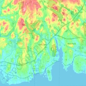
Nom : Carte topographique East Lyme, altitude, relief.
Altitude moyenne : 41 m
Altitude minimum : -3 m
Altitude maximum : 152 m
Faire un don
Équipez-vous pour votre prochaine aventure :
En tant que Partenaire Amazon, ce site perçoit une commission sur les achats éligibles sans surcoût pour vous.
Autres cartes topographiques
Cliquez sur une carte pour visualiser sa topographie, son altitude et son relief.
High Rock
United States > Connecticut > Southeastern Connecticut Planning Region > Waterford
Altitude moyenne : 39 m
Chesterfield
United States > Connecticut > Southeastern Connecticut Planning Region > Montville
Altitude moyenne : 77 m
North Franklin
United States > Connecticut > Southeastern Connecticut Planning Region
Altitude moyenne : 103 m
Faire un don
Équipez-vous pour votre prochaine aventure :
En tant que Partenaire Amazon, ce site perçoit une commission sur les achats éligibles sans surcoût pour vous.
Flanders
United States > Connecticut > Southeastern Connecticut Planning Region > East Lyme
Altitude moyenne : 43 m
Manitock Spring
United States > Connecticut > Southeastern Connecticut Planning Region > Waterford
Altitude moyenne : 26 m
Quiambaug
United States > Connecticut > Southeastern Connecticut Planning Region > Mystic
Altitude moyenne : 8 m
Oakdale
United States > Connecticut > Southeastern Connecticut Planning Region > Montville
Altitude moyenne : 141 m
Faire un don
Équipez-vous pour votre prochaine aventure :
En tant que Partenaire Amazon, ce site perçoit une commission sur les achats éligibles sans surcoût pour vous.
Austrailia Beach
United States > Connecticut > Southeastern Connecticut Planning Region > Mystic
Altitude moyenne : 19 m
Jordan Village
United States > Connecticut > Southeastern Connecticut Planning Region > Waterford
Altitude moyenne : 27 m
Giants Neck
United States > Connecticut > Southeastern Connecticut Planning Region > East Lyme
Altitude moyenne : 9 m
Uncasville
United States > Connecticut > Southeastern Connecticut Planning Region > Montville
Altitude moyenne : 40 m
Faire un don
Équipez-vous pour votre prochaine aventure :
En tant que Partenaire Amazon, ce site perçoit une commission sur les achats éligibles sans surcoût pour vous.
Flanders
United States > Connecticut > Southeastern Connecticut Planning Region > East Lyme
Altitude moyenne : 38 m
Pepperbox Hill
United States > Connecticut > Southeastern Connecticut Planning Region > Waterford
Altitude moyenne : 18 m
Austrailia Beach
United States > Connecticut > Southeastern Connecticut Planning Region > Mystic
Altitude moyenne : 19 m
Montville Center
United States > Connecticut > Southeastern Connecticut Planning Region > Montville
Altitude moyenne : 106 m
Faire un don
Équipez-vous pour votre prochaine aventure :
En tant que Partenaire Amazon, ce site perçoit une commission sur les achats éligibles sans surcoût pour vous.
Four Corners
United States > Connecticut > Southeastern Connecticut Planning Region > Montville
Altitude moyenne : 108 m
Taftville Reservoir #1 Dam
United States > Connecticut > Southeastern Connecticut Planning Region > Norwich
Altitude moyenne : 75 m
Blue Lake
United States > Connecticut > Southeastern Connecticut Planning Region > North Stonington
Altitude moyenne : 106 m
Faire un don
Équipez-vous pour votre prochaine aventure :
En tant que Partenaire Amazon, ce site perçoit une commission sur les achats éligibles sans surcoût pour vous.
Blackboys
United States > Connecticut > Southeastern Connecticut Planning Region > East Lyme
Altitude moyenne : 38 m
Quiambaug
United States > Connecticut > Southeastern Connecticut Planning Region > Mystic
Altitude moyenne : 8 m
Quaker Hill
United States > Connecticut > Southeastern Connecticut Planning Region > Waterford
Altitude moyenne : 35 m
Center Groton
United States > Connecticut > Southeastern Connecticut Planning Region > Groton
Altitude moyenne : 49 m
Faire un don
Équipez-vous pour votre prochaine aventure :
En tant que Partenaire Amazon, ce site perçoit une commission sur les achats éligibles sans surcoût pour vous.
Chesterfield
United States > Connecticut > Southeastern Connecticut Planning Region > Montville
Altitude moyenne : 77 m
Austrailia Beach
United States > Connecticut > Southeastern Connecticut Planning Region > Mystic
Altitude moyenne : 19 m
Huntley Island
United States > Connecticut > Southeastern Connecticut Planning Region > East Lyme
Altitude moyenne : 7 m
Austrailia Beach
United States > Connecticut > Southeastern Connecticut Planning Region > Mystic
Altitude moyenne : 19 m
Faire un don
Équipez-vous pour votre prochaine aventure :
En tant que Partenaire Amazon, ce site perçoit une commission sur les achats éligibles sans surcoût pour vous.
Hanover Reservoir
United States > Connecticut > Southeastern Connecticut Planning Region > Hanover
Altitude moyenne : 91 m
North Stonington
United States > Connecticut > Southeastern Connecticut Planning Region
Altitude moyenne : 73 m
Avery Hill
United States > Connecticut > Southeastern Connecticut Planning Region > Ledyard
Altitude moyenne : 52 m
Mystic
United States > Connecticut > Southeastern Connecticut Planning Region > Stonington
Altitude moyenne : 17 m
Faire un don
Équipez-vous pour votre prochaine aventure :
En tant que Partenaire Amazon, ce site perçoit une commission sur les achats éligibles sans surcoût pour vous.
Fitch Corner
United States > Connecticut > Southeastern Connecticut Planning Region > Montville
Altitude moyenne : 51 m
Seal Rocks
United States > Connecticut > Southeastern Connecticut Planning Region > Stonington
Altitude moyenne : 37 m