
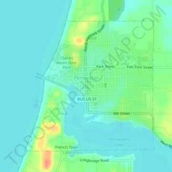
Carte topographique Pentwater
Carte interactive
Cliquez sur la carte pour afficher l’altitude.
À propos de cette carte
Nom : Carte topographique Pentwater, altitude, relief.
Altitude moyenne : 183 m
Altitude minimum : 172 m
Altitude maximum : 216 m
Autres cartes topographiques
Cliquez sur une carte pour visualiser sa topographie, son altitude et son relief.
Otto Township
United States > Michigan > Oceana County
Otto Township, Oceana County, Michigan, United States
Altitude moyenne : 210 m
Pentwater Township
United States > Michigan > Oceana County
Pentwater Township, Oceana County, Michigan, United States
Altitude moyenne : 188 m
Shelby Township
United States > Michigan > Oceana County
Shelby Township, Oceana County, Michigan, 49455, United States
Altitude moyenne : 261 m