
Carte topographique Flushing Meadows-Corona Park
Carte interactive
Cliquez sur la carte pour afficher l’altitude.
À propos de cette carte
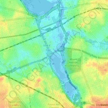
Nom : Carte topographique Flushing Meadows-Corona Park, altitude, relief.
Lieu : Flushing Meadows-Corona Park, New York, United States (40.71453 -73.86319 40.76675 -73.82557)
Altitude moyenne : 15 m
Altitude minimum : -7 m
Altitude maximum : 40 m
Around 1907, contractor Michael Degnon, whose firm constructed the Williamsburg Bridge, the Cape Cod Canal, and the Steinway subway tunnel (used by today's 7 and <7> trains), purchased large tracts of marsh near Flushing Creek. At the time, the land was considered "all but worthless". Degnon envisioned using the site to create a large industrial port around Flushing Bay, similar to a terminal he developed in Long Island City. By 1911, Degnon had created a plan along with the United States Department of War and the Queens Topographical Bureau. The plan envisioned widening Flushing River and creating docks for ships, with numerous factories and freight facilities. Meanwhile, the residential areas of Corona were expected to become the primary residence for factory workers.
Autres cartes topographiques
Cliquez sur une carte pour visualiser sa topographie, son altitude et son relief.
Staten Island
United States > New York > New York
Staten Island, Richmond County, New York, United States
Altitude moyenne : 9 m
Queens County
United States > New York > New York
Queens County, New York, United States
Altitude moyenne : 11 m
Brooklyn
United States > New York > New York
Brooklyn, Kings County, New York, United States
Altitude moyenne : 9 m
Bronx County
United States > New York > New York
Bronx County, The Bronx, New York, United States
Altitude moyenne : 21 m
Kaiser Park
United States > New York > New York
Kaiser Park, Brooklyn, Kings County, New York, United States
Altitude moyenne : 2 m
Franz Sigel Park
United States > New York > New York
Franz Sigel Park, Bronx County, The Bronx, New York, United States
Altitude moyenne : 16 m
Emerson Hill
United States > New York > New York
Emerson Hill, New York, 10304, United States
Altitude moyenne : 53 m
Sylvan Water
United States > New York > New York
Sylvan Water, Brooklyn, Kings County, New York, United States
Altitude moyenne : 25 m
Jackie Robinson Park
United States > New York > New York
Jackie Robinson Park, Brooklyn, Kings County, New York, United States
Altitude moyenne : 22 m
Queens
United States > New York > New York
Queens, Queens County, New York, United States
Altitude moyenne : 12 m
Lawrence Point
United States > New York > New York
Lawrence Point, Queens County, New York, 11105, United States
Altitude moyenne : 4 m
The Bronx
United States > New York > New York
The Bronx, New York, United States
Altitude moyenne : 23 m
Flushing Bay
United States > New York > New York
Flushing Bay, Queens County, New York, 11356, United States
Altitude moyenne : 4 m
Gowanus Canal
United States > New York > New York
Gowanus Canal, Kings County, New York, 11231, United States
Altitude moyenne : 11 m
Fort Greene Park
United States > New York > New York
Fort Greene Park, Brooklyn, Kings County, New York, United States
Altitude moyenne : 17 m
New York County
United States > New York > New York
New York County, New York, United States
Altitude moyenne : 16 m
Prospect Park
United States > New York > New York
Prospect Park, Kings County, New York, United States
Altitude moyenne : 34 m
Willets Point
United States > New York > New York
Willets Point, Queens County, New York, 11359, United States
Altitude moyenne : 2 m
Jamaica Bay Wildlife Refuge
United States > New York > New York
Jamaica Bay Wildlife Refuge, Queens County, New York, 11694, United States
Altitude moyenne : 1 m
Flushing Meadows Scenic Viewpoint
United States > New York > New York
Flushing Meadows Scenic Viewpoint, Pat Dolan Trail, Kew Gardens, Queens, New York, 11375, United States
Altitude moyenne : 22 m
Coastline access
United States > New York > New York
Coastline access, Brooklyn, Kings County, New York, United States
Altitude moyenne : 3 m
Bowery Bay
United States > New York > New York
Bowery Bay, Queens County, New York, 11371, United States
Altitude moyenne : 5 m
Richmond County
United States > New York > New York
Richmond County, New York, United States
Altitude moyenne : 9 m
Kings County
United States > New York > New York
Kings County, New York, United States
Altitude moyenne : 9 m
Barren Island
United States > New York > New York
Barren Island, New York, 11697, United States
Altitude moyenne : 16 m