
Faire un don
Équipez-vous pour votre prochaine aventure :
En tant que Partenaire Amazon, ce site perçoit une commission sur les achats éligibles sans surcoût pour vous.
Carte topographique Goodland
Cliquez sur la carte pour afficher l’altitude.
Faire un don
Équipez-vous pour votre prochaine aventure :
En tant que Partenaire Amazon, ce site perçoit une commission sur les achats éligibles sans surcoût pour vous.
Goodland
Goodland is located at 39°21′3″N 101°42′37″W / 39.35083°N 101.71028°W / 39.35083; -101.71028 (39.3508330, −101.7101722) at an elevation of 3,681 feet (1,122 m). It lies on the south side of the Middle Fork of Sappa Creek, part of the Republican River watershed, in the High Plains region of the Great Plains. Located at the intersection of Interstate 70 and K-27 in northwest Kansas, Goodland is roughly 17 miles (27 km) east of the Colorado state line, 176 miles east-southeast of Denver, 265 miles (426 km) northwest of Wichita, and 383 miles (616 km) west of Kansas City.
Faire un don
Équipez-vous pour votre prochaine aventure :
En tant que Partenaire Amazon, ce site perçoit une commission sur les achats éligibles sans surcoût pour vous.
À propos de cette carte
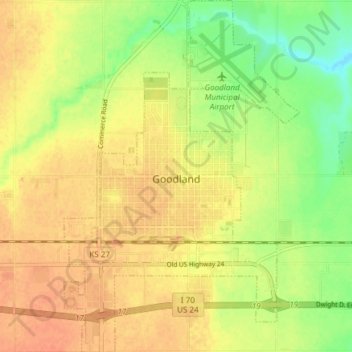
Nom : Carte topographique Goodland, altitude, relief.
Lieu : Goodland, Sherman County, Kansas, 67735, United States (39.32218 -101.73418 39.38030 -101.68377)
Altitude moyenne : 1 120 m
Altitude minimum : 1 097 m
Altitude maximum : 1 134 m
Faire un don
Équipez-vous pour votre prochaine aventure :
En tant que Partenaire Amazon, ce site perçoit une commission sur les achats éligibles sans surcoût pour vous.