
Carte topographique Shenyang City
Carte interactive
Cliquez sur la carte pour afficher l’altitude.
À propos de cette carte
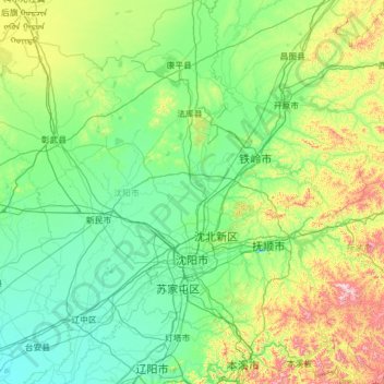
Nom : Carte topographique Shenyang City, altitude, relief.
Lieu : Shenyang City, Liaoning, China (41.19769 122.41674 43.04030 123.80854)
Altitude moyenne : 155 m
Altitude minimum : 3 m
Altitude maximum : 1 101 m
Shenyang ranges in latitude from 41° 11' to 43° 02' N and in longitude from 122° 25' to 123° 48' E, and is located in the central part of Liaoning province. The western parts of the city's administrative area are located on the alluvial plain of the Liao River system, while the eastern part consists of the hinterlands of the Changbai Mountains, and is covered with forests. The highest point in Shenyang is 414 m (1,358 ft) above sea level and the lowest point only 7 m (23 ft). The average elevation of the urban area is 45 m (148 ft).
Autres cartes topographiques
Cliquez sur une carte pour visualiser sa topographie, son altitude et son relief.
Taiping District
Taiping District, Fuxin City, Liaoning, 123000, China
Altitude moyenne : 235 m
Dalian
China > Liaoning > Dalian > Qingniwaqiao Subdistrict
Dalian, Qingniwaqiao Subdistrict, Zhongshan District, Dalian City, Liaoning, 116011, China
Altitude moyenne : 27 m