
Faire un don
Équipez-vous pour votre prochaine aventure :
En tant que Partenaire Amazon, ce site perçoit une commission sur les achats éligibles sans surcoût pour vous.
Carte topographique Azour
Cliquez sur la carte pour afficher l’altitude.
Faire un don
Équipez-vous pour votre prochaine aventure :
En tant que Partenaire Amazon, ce site perçoit une commission sur les achats éligibles sans surcoût pour vous.
À propos de cette carte
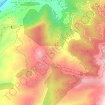
Nom : Carte topographique Azour, altitude, relief.
Lieu : Azour, Jezzine District, South Governorate, 6662, Lebanon (33.53949 35.51518 33.57949 35.55518)
Altitude moyenne : 731 m
Altitude minimum : 236 m
Altitude maximum : 1 069 m
Faire un don
Équipez-vous pour votre prochaine aventure :
En tant que Partenaire Amazon, ce site perçoit une commission sur les achats éligibles sans surcoût pour vous.
Autres cartes topographiques
Cliquez sur une carte pour visualiser sa topographie, son altitude et son relief.
Faire un don
Équipez-vous pour votre prochaine aventure :
En tant que Partenaire Amazon, ce site perçoit une commission sur les achats éligibles sans surcoût pour vous.
Faire un don
Équipez-vous pour votre prochaine aventure :
En tant que Partenaire Amazon, ce site perçoit une commission sur les achats éligibles sans surcoût pour vous.
Sidon
The city of Sidon is administered by the Municipality of Sidon. The municipality is constituted of a council of 21 members including the City Mayor and his Deputy. It has administrative and financial independence but remains under the control and supervision of the central government, specifically the Ministry…
Altitude moyenne : 44 m
Sidon
The city of Sidon is administered by the Municipality of Sidon. The municipality is constituted of a council of 21 members including the City Mayor and his Deputy. It has administrative and financial independence but remains under the control and supervision of the central government, specifically the Ministry…
Altitude moyenne : 38 m
Faire un don
Équipez-vous pour votre prochaine aventure :
En tant que Partenaire Amazon, ce site perçoit une commission sur les achats éligibles sans surcoût pour vous.
Sidon
The city of Sidon is administered by the Municipality of Sidon. The municipality is constituted of a council of 21 members including the City Mayor and his Deputy. It has administrative and financial independence but remains under the control and supervision of the central government, specifically the Ministry…
Altitude moyenne : 38 m
Tyre
Since 2008, a Lebanese-French team under the direction by Pierre-Louis Gatier of the University of Lyon has been conducting archaeological and topographical work. When international archeological missions in Syria came to a halt after 2012 due to the war there, some of them instead started excavations in Tyre,…
Altitude moyenne : 5 m
Tyre
Since 2008, a Lebanese French team under the direction by Pierre-Louis Gatier of the University of Lyon has been conducting archaeological and topographical work. When international archeological missions in Syria came to a halt after 2012 due to the war there, some of them instead started excavations in Tyre,…
Altitude moyenne : 5 m
Faire un don
Équipez-vous pour votre prochaine aventure :
En tant que Partenaire Amazon, ce site perçoit une commission sur les achats éligibles sans surcoût pour vous.