
Faire un don
Équipez-vous pour votre prochaine aventure :
En tant que Partenaire Amazon, ce site perçoit une commission sur les achats éligibles sans surcoût pour vous.
Carte topographique Fort Mountain
Cliquez sur la carte pour afficher l’altitude.
Faire un don
Équipez-vous pour votre prochaine aventure :
En tant que Partenaire Amazon, ce site perçoit une commission sur les achats éligibles sans surcoût pour vous.
Fort Mountain
On June 20, 1944, a C-54-A cargo plane on the Newfoundland to Washington, D.C. leg of trans-Atlantic TWA Flight 277 from England was pushed 70 miles (110 km) north of its planned course by stormy weather, which prevented obtaining visual or radio location fixes. The crew was unaware the aircraft had entered mountainous terrain and was still flying at the 4,000-foot (1,200 m) elevation appropriate for passing over Bangor, Maine. The single passenger and all six crewmen were killed when the aircraft hit Fort Mountain. The aircraft burned, but some large pieces are still accessible and reasonably well preserved.
Faire un don
Équipez-vous pour votre prochaine aventure :
En tant que Partenaire Amazon, ce site perçoit une commission sur les achats éligibles sans surcoût pour vous.
À propos de cette carte
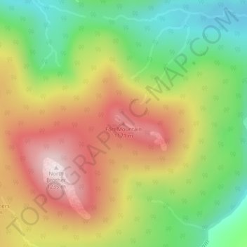
Nom : Carte topographique Fort Mountain, altitude, relief.
Altitude moyenne : 944 m
Altitude minimum : 668 m
Altitude maximum : 1 248 m
Faire un don
Équipez-vous pour votre prochaine aventure :
En tant que Partenaire Amazon, ce site perçoit une commission sur les achats éligibles sans surcoût pour vous.