Géolocaliser

Carte topographique 闾井镇

Carte interactive

Cliquez sur la carte pour afficher l’altitude.

À propos de cette carte

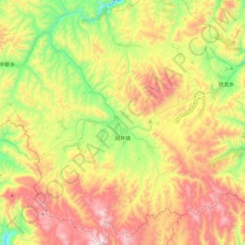
Nom : Carte topographique 闾井镇, altitude, relief.

Lieu : 闾井镇, 岷县, 定西市, 甘肃省, 中国 (34.19409 104.39564 34.48102 104.69159)

Altitude moyenne : 2 814 m

Altitude minimum : 2 295 m

Altitude maximum : 3 476 m

Autres cartes topographiques

Cliquez sur une carte pour visualiser sa topographie, son altitude et son relief.

土地眼

中国 > 甘肃省 > 岷县 > 马坞镇

土地眼, 马坞镇, 岷县, 定西市, 甘肃省, 中国

Altitude moyenne : 2 349 m

岷县龙望台水电集团有限责任公司

中国 > 甘肃省 > 岷县 > 的西

岷县龙望台水电集团有限责任公司, 的西, 岷县, 定西市, 甘肃省, 中国

Altitude moyenne : 2 446 m

岷县

中国 > 甘肃省 > 岷县

岷县, 定西市, 甘肃省, 748400, 中国

Altitude moyenne : 2 695 m

二郎山

中国 > 甘肃省 > 岷县 > 岷县

二郎山, 岷县, 定西市, 甘肃省, 74800, 中国

Altitude moyenne : 2 356 m

岷山

中国 > 甘肃省 > 岷县

岷山, 岷县, 定西市, 甘肃省, 中国

Altitude moyenne : 2 403 m