
Faire un don
Équipez-vous pour votre prochaine aventure :
En tant que Partenaire Amazon, ce site perçoit une commission sur les achats éligibles sans surcoût pour vous.
Carte topographique Interlochen
Cliquez sur la carte pour afficher l’altitude.
Faire un don
Équipez-vous pour votre prochaine aventure :
En tant que Partenaire Amazon, ce site perçoit une commission sur les achats éligibles sans surcoût pour vous.
À propos de cette carte
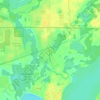
Nom : Carte topographique Interlochen, altitude, relief.
Altitude moyenne : 258 m
Altitude minimum : 247 m
Altitude maximum : 268 m
Faire un don
Équipez-vous pour votre prochaine aventure :
En tant que Partenaire Amazon, ce site perçoit une commission sur les achats éligibles sans surcoût pour vous.
Autres cartes topographiques
Cliquez sur une carte pour visualiser sa topographie, son altitude et son relief.
Traverse City
United States > Michigan > Grand Traverse County
The locale and topography is conducive for road bicycling, aided by the TART trail system. A map with routes, different trips, advice and local knowledge is available. Lake Michigan presents a location for sailing, fishing, and kayaking.
Altitude moyenne : 204 m
Faire un don
Équipez-vous pour votre prochaine aventure :
En tant que Partenaire Amazon, ce site perçoit une commission sur les achats éligibles sans surcoût pour vous.
Grand Traverse Commons Natural Area
United States > Michigan > Grand Traverse County > Traverse City
Altitude moyenne : 203 m
Faire un don
Équipez-vous pour votre prochaine aventure :
En tant que Partenaire Amazon, ce site perçoit une commission sur les achats éligibles sans surcoût pour vous.
Traverse City
United States > Michigan > Grand Traverse County
The locale and topography is conducive for road bicycling, aided by the TART trail system. A map with routes, different trips, advice and local knowledge is available. Lake Michigan presents a location for sailing, fishing, and kayaking.
Altitude moyenne : 204 m
Faire un don
Équipez-vous pour votre prochaine aventure :
En tant que Partenaire Amazon, ce site perçoit une commission sur les achats éligibles sans surcoût pour vous.
Faire un don
Équipez-vous pour votre prochaine aventure :
En tant que Partenaire Amazon, ce site perçoit une commission sur les achats éligibles sans surcoût pour vous.