
Carte topographique Khartoum
Carte interactive
Cliquez sur la carte pour afficher l’altitude.
À propos de cette carte
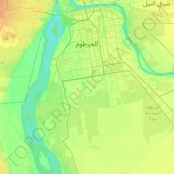
Nom : Carte topographique Khartoum, altitude, relief.
Lieu : Khartoum, Khartoum State, Sudan (15.38765 32.45915 15.61680 32.71226)
Altitude moyenne : 384 m
Altitude minimum : 372 m
Altitude maximum : 398 m
Khartoum is relatively flat, at elevation 385 m (1,263 ft), as the Nile flows northeast past Omdurman to Shendi, at elevation 364 m (1,194 ft) about 101 mi (163 km) away.
Autres cartes topographiques
Cliquez sur une carte pour visualiser sa topographie, son altitude et son relief.
Jebel Aulia Dam
Sudan > Khartoum State > Jebel Aulia
Jebel Aulia Dam, Jebel Aulia, Khartoum State, Sudan
Altitude moyenne : 380 m
Khartoum
Sudan > Khartoum State > Khartoum
Khartoum, Khartoum State, 11111, Sudan
Altitude moyenne : 388 m
The River Nile
Sudan > Khartoum State > Bahri
The River Nile, Bahri, Khartoum State, Sudan
Altitude moyenne : 389 m
Jebel Aulia
Sudan > Khartoum State > Jebel Aulia
Jebel Aulia, Khartoum State, Sudan
Altitude moyenne : 382 m