
Carte topographique Quetta
Carte interactive
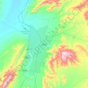
Cliquez sur la carte pour afficher l’altitude.
À propos de cette carte
Nom : Carte topographique Quetta, altitude, relief.
Lieu : Quetta, Mastung District, Balochistan, 87300, Pakistan (30.03574 66.85725 30.35574 67.17725)
Altitude moyenne : 1 968 m
Altitude minimum : 1 538 m
Altitude maximum : 3 180 m
Quetta (Pashto: کوټه Kwaṭa; Balochi: کویته; Hazaragi: کوٹه; Urdu: کوئٹہ; (listen); formerly known as Shalkot (Pashto: شالکوټ) is the provincial capital and largest city of Balochistan, Pakistan. It is also the 10th largest city of Pakistan. It was largely destroyed in the 1935 Quetta earthquake, but was rebuilt and has a population of 1,001,205 according to the census of 2017. Quetta is at an average elevation of 1,680 metres (5,510 feet) above sea level, making it Pakistan's only high-altitude major city. The city is known as the "Fruit Garden of Pakistan," due to the numerous fruit orchards in and around it, and the large variety of fruits and dried fruit products produced there.
Autres cartes topographiques
Cliquez sur une carte pour visualiser sa topographie, son altitude et son relief.
Hanna Lake
Pakistan > Balochistan > Quetta
Hanna Lake, Quetta Road, Cantonment, Quetta, Ziārat District, Balochistan, 87300, Pakistan
Altitude moyenne : 1 957 m