Géolocaliser

Carte topographique Pangarchulla

Cliquez sur la carte pour afficher l’altitude.

À propos de cette carte
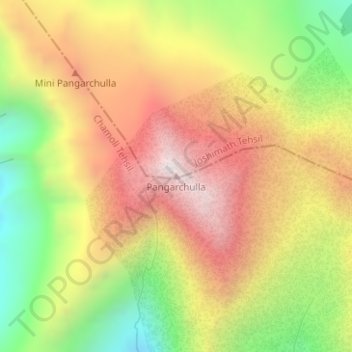
Nom : Carte topographique Pangarchulla, altitude, relief.

Lieu : Pangarchulla, Joshimath Tehsil, Chamoli, Uttarakhand, 246483, India (30.42362 79.59209 30.42372 79.59219)

Altitude moyenne : 4 061 m

Altitude minimum : 3 494 m

Altitude maximum : 4 570 m

Autres cartes topographiques

Cliquez sur une carte pour visualiser sa topographie, son altitude et son relief.
Hemkund

India > Uttarakhand > Joshimath Tehsil

Altitude moyenne : 4 367 m

Mana

India > Uttarakhand > Joshimath Tehsil

Altitude moyenne : 4 959 m

Saraswati

India > Uttarakhand > Joshimath Tehsil > Mana

Altitude moyenne : 5 393 m

Nanda Ghunti Glacier

India > Uttarakhand > Joshimath Tehsil

Altitude moyenne : 5 086 m

Équipez-vous pour votre prochaine aventure :

🕶️Lunettes de soleil sport - Lunettes filtrantes pour activités en plein air
🔪Couteau de Poche - L'outil indispensable pour toutes les situations en extérieur.
🗡️Couteaux outdoor - Couteaux polyvalents pour randonnée et camping
👕T-shirt Laine Mérinos - Régulation thermique naturelle et anti-odeurs.
⛸️Crampons de Chaussures - Sécurité antidérapante sur les sentiers verglacés.

En tant que Partenaire Amazon, ce site perçoit une commission sur les achats éligibles sans surcoût pour vous.