
Carte topographique Jonesville
Carte interactive
Cliquez sur la carte pour afficher l’altitude.
À propos de cette carte
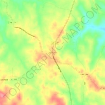
Nom : Carte topographique Jonesville, altitude, relief.
Lieu : Jonesville, Hart County, Kentucky, 42757, United States (37.36784 -85.78830 37.40784 -85.74830)
Altitude moyenne : 241 m
Altitude minimum : 195 m
Altitude maximum : 283 m
Autres cartes topographiques
Cliquez sur une carte pour visualiser sa topographie, son altitude et son relief.
Lone Star
United States > Kentucky > Hart County
Lone Star, Hart County, Kentucky, 42713, United States
Altitude moyenne : 228 m
Uno
United States > Kentucky > Hart County
Uno, Hart County, Kentucky, United States
Altitude moyenne : 201 m
Hardyville
United States > Kentucky > Hart County
Hardyville, Hart County, Kentucky, United States
Altitude moyenne : 212 m
Canmer
United States > Kentucky > Hart County
Canmer, Hart County, Kentucky, United States
Altitude moyenne : 185 m
Bee
United States > Kentucky > Hart County
Bee, Hart County, Kentucky, 42729, United States
Altitude moyenne : 230 m
Big Windy
United States > Kentucky > Hart County
Big Windy, Hart County, Kentucky, 42729, United States
Altitude moyenne : 206 m
Hammonville
United States > Kentucky > Hart County
Hammonville, Hart County, Kentucky, United States
Altitude moyenne : 232 m
Northtown
United States > Kentucky > Hart County
Northtown, Hart County, Kentucky, United States
Altitude moyenne : 225 m
Woodsonville
United States > Kentucky > Hart County
Woodsonville, Hart County, Kentucky, 42765, United States
Altitude moyenne : 183 m
Munfordville
United States > Kentucky > Hart County
Munfordville, Hart County, Kentucky, United States
Altitude moyenne : 191 m
Kessinger
United States > Kentucky > Hart County
Kessinger, Hart County, Kentucky, 42765, United States
Altitude moyenne : 260 m
Rowletts
United States > Kentucky > Hart County
Rowletts, Hart County, Kentucky, United States
Altitude moyenne : 197 m
Horse Cave
United States > Kentucky > Hart County
Horse Cave, Hart County, Kentucky, United States
Altitude moyenne : 207 m
Bonnieville
United States > Kentucky > Hart County
Bonnieville, Hart County, Kentucky, 42713, United States
Altitude moyenne : 212 m
Cub Run
United States > Kentucky > Hart County
Cub Run, Hart County, Kentucky, 42729, United States
Altitude moyenne : 225 m
Monroe
United States > Kentucky > Hart County
Monroe, Hart County, Kentucky, 42746, United States
Altitude moyenne : 210 m