Géolocaliser

Carte topographique 白鹿镇

Carte interactive

Cliquez sur la carte pour afficher l’altitude.

À propos de cette carte

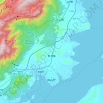
Nom : Carte topographique 白鹿镇, altitude, relief.

Lieu : 白鹿镇, 庐山市, 九江市, 江西省, 中国 (29.44633 115.95984 29.53967 116.13731)

Altitude moyenne : 228 m

Altitude minimum : 7 m

Altitude maximum : 1 451 m

Autres cartes topographiques

Cliquez sur une carte pour visualiser sa topographie, son altitude et son relief.

庐山市

中国 > 江西省 > 庐山市 > 南康镇

庐山市, 南康镇, 庐山市, 九江市, 江西省, 中国

Altitude moyenne : 141 m

杨柳津河

中国 > 江西省 > 庐山市 > 沙湖山管理处

杨柳津河, 沙湖山管理处, 庐山市, 九江市, 江西省, 中国

Altitude moyenne : 15 m

三叠泉

中国 > 江西省 > 庐山市 > 海会镇

三叠泉, 海会镇, 庐山市, 九江市, 江西省, 中国

Altitude moyenne : 794 m

庐山植物园

中国 > 江西省 > 庐山市 > 牯岭镇 > 朝阳村

庐山植物园, 朝阳村, 牯岭镇, 庐山市, 九江市, 江西省, 中国

Altitude moyenne : 1 031 m

沙湖山管理处

中国 > 江西省 > 庐山市 > 沙湖山管理处

沙湖山管理处, 庐山市, 九江市, 江西省, 中国

Altitude moyenne : 16 m