
Faire un don
Équipez-vous pour votre prochaine aventure :
En tant que Partenaire Amazon, ce site perçoit une commission sur les achats éligibles sans surcoût pour vous.
Carte topographique Wytheville
Cliquez sur la carte pour afficher l’altitude.
Faire un don
Équipez-vous pour votre prochaine aventure :
En tant que Partenaire Amazon, ce site perçoit une commission sur les achats éligibles sans surcoût pour vous.
Wytheville
Due to its elevation, the climate of Wytheville is either classified as mountain temperate or humid subtropical (Köppen Cfb or Cfa, respectively), and the town straddles the border between USDA Plant Hardiness Zones 6B and 7A. Summers are warm and humid, although significantly cooler than low-elevation places within the state, with only 4.6 days of 90 °F (32 °C)+ highs annually, and winters are generally cool to cold with occasional intervening warm periods and 11 nights of sub-10 °F (−12 °C) lows. Monthly mean temperatures range from 32.9 °F (0.5 °C) in January to 71.7 °F (22.1 °C) in July. Snowfall averages 20.5 inches (52 cm) per season and generally occurs from December to March.
Faire un don
Équipez-vous pour votre prochaine aventure :
En tant que Partenaire Amazon, ce site perçoit une commission sur les achats éligibles sans surcoût pour vous.
À propos de cette carte
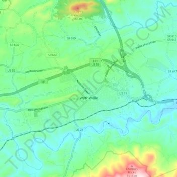
Nom : Carte topographique Wytheville, altitude, relief.
Lieu : Wytheville, Wythe County, Virginia, 24382, United States (36.92258 -81.13589 36.98165 -81.03117)
Altitude moyenne : 720 m
Altitude minimum : 621 m
Altitude maximum : 1 059 m
Faire un don
Équipez-vous pour votre prochaine aventure :
En tant que Partenaire Amazon, ce site perçoit une commission sur les achats éligibles sans surcoût pour vous.
Autres cartes topographiques
Cliquez sur une carte pour visualiser sa topographie, son altitude et son relief.
Faire un don
Équipez-vous pour votre prochaine aventure :
En tant que Partenaire Amazon, ce site perçoit une commission sur les achats éligibles sans surcoût pour vous.
Stones Mill
United States > Virginia > Wythe County > Wytheville > Stones Mill
Altitude moyenne : 710 m
Faire un don
Équipez-vous pour votre prochaine aventure :
En tant que Partenaire Amazon, ce site perçoit une commission sur les achats éligibles sans surcoût pour vous.