
Carte topographique Rashang
Carte interactive
Cliquez sur la carte pour afficher l’altitude.
À propos de cette carte
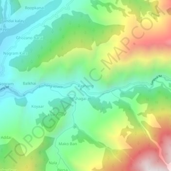
Nom : Carte topographique Rashang, altitude, relief.
Altitude moyenne : 1 916 m
Altitude minimum : 1 473 m
Altitude maximum : 2 757 m
Autres cartes topographiques
Cliquez sur une carte pour visualiser sa topographie, son altitude et son relief.
Pokal
Pakistan > Khyber Pakhtunkhwa > Battagram District > Allai Tehsil
Pokal, Allai Tehsil, Battagram District, Hazara Division, Khyber Pakhtunkhwa, 21010, Pakistan
Altitude moyenne : 1 649 m