
Carte topographique Monongahela National Forest
Carte interactive
Cliquez sur la carte pour afficher l’altitude.
À propos de cette carte
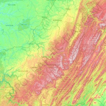
Nom : Carte topographique Monongahela National Forest, altitude, relief.
Altitude moyenne : 655 m
Altitude minimum : 191 m
Altitude maximum : 1 474 m
In 1943 and 1944, as part of the West Virginia Maneuver Area, the U.S. Army used parts of the Monongahela National Forest as a practice artillery and mortar range and maneuver area before troops were sent to Europe to fight in World War II. Artillery and mortar shells shot into the area for practice are still occasionally found there today. Seneca Rocks and other area cliffs were also used for assault climbing instruction. This was the Army's only low-altitude climbing school.
Autres cartes topographiques
Cliquez sur une carte pour visualiser sa topographie, son altitude et son relief.
Denmar
United States > West Virginia > Pocahontas County
Denmar, Pocahontas County, West Virginia, 24946, United States
Altitude moyenne : 690 m
Green Bank Telescope
United States > West Virginia > Pocahontas County
Green Bank Telescope, Slavin Hollow Road, Pocahontas County, West Virginia, 24944, United States
Altitude moyenne : 822 m
Marlinton
United States > West Virginia > Pocahontas County > Marlinton
Marlinton, Pocahontas County, West Virginia, 24924, United States
Altitude moyenne : 791 m
Hillsboro
United States > West Virginia > Pocahontas County > Hillsboro
Hillsboro, Pocahontas County, West Virginia, United States
Altitude moyenne : 706 m
Walnut
United States > West Virginia > Pocahontas County > Walnut
Walnut, Pocahontas County, West Virginia, 26291, United States
Altitude moyenne : 1 041 m
Frank
United States > West Virginia > Pocahontas County
Frank, Pocahontas County, West Virginia, 26264, United States
Altitude moyenne : 926 m
Cass
United States > West Virginia > Pocahontas County > Cass
Cass, Pocahontas County, West Virginia, United States
Altitude moyenne : 839 m