
Carte topographique Rettenbach
Carte interactive
Cliquez sur la carte pour afficher l’altitude.
À propos de cette carte
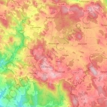
Nom : Carte topographique Rettenbach, altitude, relief.
Altitude moyenne : 579 m
Altitude minimum : 405 m
Altitude maximum : 681 m
Autres cartes topographiques
Cliquez sur une carte pour visualiser sa topographie, son altitude et son relief.
Kapelhof
Duitsland > Beieren > Landkreis Cham > Roding
Kapelhof, Roding, Landkreis Cham, Beieren, 93426, Duitsland
Altitude moyenne : 427 m