
Carte topographique Puthuppally
Carte interactive
Cliquez sur la carte pour afficher l’altitude.
À propos de cette carte
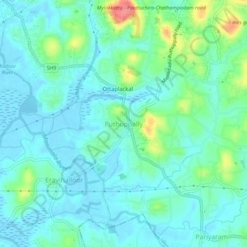
Nom : Carte topographique Puthuppally, altitude, relief.
Lieu : Puthuppally, Kottayam, Kerala, 686011, India (9.53930 76.55194 9.57930 76.59194)
Altitude moyenne : 18 m
Altitude minimum : -3 m
Altitude maximum : 79 m
Autres cartes topographiques
Cliquez sur une carte pour visualiser sa topographie, son altitude et son relief.
Thiruvanchoor
India > Kerala > Kottayam > Thiruvanchoor
Thiruvanchoor, Kottayam, Kerala, 686637, India
Altitude moyenne : 11 m
Karappuzha Temple Kulam
India > Kerala > Kottayam > Kottayam
Karappuzha Temple Kulam, Kottayam, Kerala, India
Altitude moyenne : 6 m
Mattakkara
India > Kerala > Kottayam > Mattakkara
Mattakkara, Kottayam, Kerala, 686564, India
Altitude moyenne : 41 m