
Faire un don
Équipez-vous pour votre prochaine aventure :
En tant que Partenaire Amazon, ce site perçoit une commission sur les achats éligibles sans surcoût pour vous.
Carte topographique Tiruvannamalai
Cliquez sur la carte pour afficher l’altitude.
Faire un don
Équipez-vous pour votre prochaine aventure :
En tant que Partenaire Amazon, ce site perçoit une commission sur les achats éligibles sans surcoût pour vous.
Tiruvannamalai
Located on the foothills of Annamalai hills, Tiruvannamalai has been ruled by the Pallavas, the Medieval Cholas, the Later Cholas, Hoysalas, the Vijayanagar Empire, the Carnatic kingdom, Tipu Sultan, and the British. It served as the capital of the Hoysalas. The town is built around the Annamalaiyar Temple like other Nayak capitals. Tiruvannamalai is administered by a special-grade a municipality constituted in 1886. Tiruvannamalai has an average elevation of 200 metres (660 ft) and experiences a hot and humid climate. Being a pilgrimage town, most of the people are employed in the tertiary sector. There are 25 elementary schools, nine high schools, 18 higher secondary schools, four arts & science colleges, one government medical college and four engineering colleges in the town.
Faire un don
Équipez-vous pour votre prochaine aventure :
En tant que Partenaire Amazon, ce site perçoit une commission sur les achats éligibles sans surcoût pour vous.
À propos de cette carte
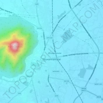
Nom : Carte topographique Tiruvannamalai, altitude, relief.
Lieu : Tiruvannamalai, Tiruvanamalai District, Tamil Nadu, India (12.21239 79.05339 12.26409 79.08889)
Altitude moyenne : 202 m
Altitude minimum : 149 m
Altitude maximum : 788 m
Faire un don
Équipez-vous pour votre prochaine aventure :
En tant que Partenaire Amazon, ce site perçoit une commission sur les achats éligibles sans surcoût pour vous.