
Faire un don
Équipez-vous pour votre prochaine aventure :
En tant que Partenaire Amazon, ce site perçoit une commission sur les achats éligibles sans surcoût pour vous.
Carte topographique Platina
Cliquez sur la carte pour afficher l’altitude.
Faire un don
Équipez-vous pour votre prochaine aventure :
En tant que Partenaire Amazon, ce site perçoit une commission sur les achats éligibles sans surcoût pour vous.
À propos de cette carte
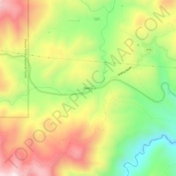
Nom : Carte topographique Platina, altitude, relief.
Lieu : Platina, Shasta County, California, 96076, United States (40.33959 -122.91474 40.37959 -122.87474)
Altitude moyenne : 770 m
Altitude minimum : 420 m
Altitude maximum : 1 136 m
Faire un don
Équipez-vous pour votre prochaine aventure :
En tant que Partenaire Amazon, ce site perçoit une commission sur les achats éligibles sans surcoût pour vous.
Autres cartes topographiques
Cliquez sur une carte pour visualiser sa topographie, son altitude et son relief.
Redding
United States > California > Shasta County
The elevation in Redding is 495 feet (151 meters) on average, whereas anywhere to the north, east, or west of downtown ranges between 550 feet (170 m) and 800 feet (240 m) feet. Southern portions range between 400 feet (120 m) and 500 feet (150 m).
Altitude moyenne : 241 m
Faire un don
Équipez-vous pour votre prochaine aventure :
En tant que Partenaire Amazon, ce site perçoit une commission sur les achats éligibles sans surcoût pour vous.
Faire un don
Équipez-vous pour votre prochaine aventure :
En tant que Partenaire Amazon, ce site perçoit une commission sur les achats éligibles sans surcoût pour vous.
Whiskeytown-Shasta-Trinity National Recreation Area - Shasta Unit
United States > California > Shasta County
Altitude moyenne : 612 m
Lassen Volcanic National Park
United States > California > Shasta County
According to the Köppen climate classification system, Lassen Volcanic National Park has a Mediterranean-influenced warm-summer Humid continental climate (Dsb). According to the United States Department of Agriculture, the Plant Hardiness zone at Kohm Yah-mah-nee Visitor Center at 6,736 ft (2,053 m) elevation…
Altitude moyenne : 1 972 m
Redding
United States > California > Shasta County
The elevation in Redding is 495 feet (151 meters) on average, whereas anywhere to the north, east, or west of downtown ranges between 550 feet (170 m) and 800 feet (240 m) feet. Southern portions range between 400 feet (120 m) and 500 feet (150 m).
Altitude moyenne : 240 m
Faire un don
Équipez-vous pour votre prochaine aventure :
En tant que Partenaire Amazon, ce site perçoit une commission sur les achats éligibles sans surcoût pour vous.
Lassen Volcanic National Park
United States > California > Shasta County
According to the Köppen climate classification system, Lassen Volcanic National Park has a Mediterranean-influenced warm-summer Humid continental climate (Dsb). According to the United States Department of Agriculture, the Plant Hardiness zone at Kohm Yah-mah-nee Visitor Center at 6,736 ft (2,053 m) elevation…
Altitude moyenne : 1 972 m
Redding
United States > California > Shasta County
The elevation in Redding is 495 feet (151 meters) on average, whereas anywhere to the north, east, or west of downtown ranges between 550 and 800 feet (170 and 240 m). Southern portions range between 400 and 500 feet (120 and 150 m).
Altitude moyenne : 241 m
Faire un don
Équipez-vous pour votre prochaine aventure :
En tant que Partenaire Amazon, ce site perçoit une commission sur les achats éligibles sans surcoût pour vous.
Faire un don
Équipez-vous pour votre prochaine aventure :
En tant que Partenaire Amazon, ce site perçoit une commission sur les achats éligibles sans surcoût pour vous.
Lassen Volcanic National Park
United States > California > Shasta County
According to the Köppen climate classification system, Lassen Volcanic National Park has a Mediterranean-influenced warm-summer Humid continental climate (Dsb). According to the United States Department of Agriculture, the Plant Hardiness zone at Kohm Yah-mah-nee Visitor Center at 6,736 ft (2,053 m) elevation…
Altitude moyenne : 1 972 m
Palo Cedro
United States > California > Shasta County
Palo Cedro is located at 40°33′4″N 122°14′3″W / 40.55111°N 122.23417°W / 40.55111; -122.23417 (40.551091, −122.234255) at an elevation of 465 ft (143 m) above sea level.
Altitude moyenne : 157 m
Faire un don
Équipez-vous pour votre prochaine aventure :
En tant que Partenaire Amazon, ce site perçoit une commission sur les achats éligibles sans surcoût pour vous.
Palo Cedro
United States > California > Shasta County
Palo Cedro is located at 40°33′4″N 122°14′3″W / 40.55111°N 122.23417°W / 40.55111; -122.23417 (40.551091, −122.234255) at an elevation of 465 ft (143 m) above sea level.
Altitude moyenne : 157 m
Whiskeytown-Shasta-Trinity National Recreation Area - Shasta Unit
United States > California > Shasta County
Altitude moyenne : 612 m