
Faire un don
Équipez-vous pour votre prochaine aventure :
En tant que Partenaire Amazon, ce site perçoit une commission sur les achats éligibles sans surcoût pour vous.
Carte topographique Blackburn
Cliquez sur la carte pour afficher l’altitude.
Faire un don
Équipez-vous pour votre prochaine aventure :
En tant que Partenaire Amazon, ce site perçoit une commission sur les achats éligibles sans surcoût pour vous.
À propos de cette carte
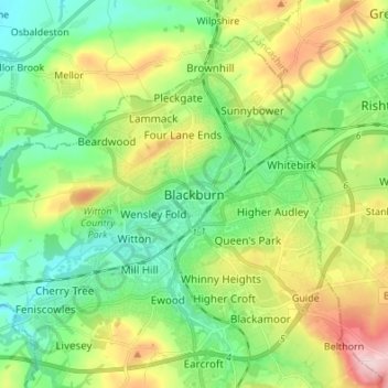
Nom : Carte topographique Blackburn, altitude, relief.
Altitude moyenne : 157 m
Altitude minimum : 77 m
Altitude maximum : 314 m
Faire un don
Équipez-vous pour votre prochaine aventure :
En tant que Partenaire Amazon, ce site perçoit une commission sur les achats éligibles sans surcoût pour vous.
Autres cartes topographiques
Cliquez sur une carte pour visualiser sa topographie, son altitude et son relief.
Darwen
United Kingdom > England > Blackburn with Darwen
The tower, which is open to the public, overlooks the town from the moors and stands at an altitude of 1,227 ft (374m) and has a height of 85 ft (26m). A spiral staircase leads to the top from where, on a clear day, Blackpool Tower, the Isle of Man, North Wales and the Furness Peninsula can be seen. In…
Altitude moyenne : 259 m
Turton & Entwistle Reservoir
United Kingdom > England > Blackburn with Darwen
Altitude moyenne : 248 m
Faire un don
Équipez-vous pour votre prochaine aventure :
En tant que Partenaire Amazon, ce site perçoit une commission sur les achats éligibles sans surcoût pour vous.
Faire un don
Équipez-vous pour votre prochaine aventure :
En tant que Partenaire Amazon, ce site perçoit une commission sur les achats éligibles sans surcoût pour vous.