
Carte topographique Otsego Township
Carte interactive
Cliquez sur la carte pour afficher l’altitude.
À propos de cette carte
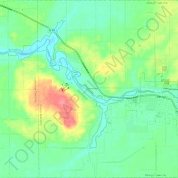
Nom : Carte topographique Otsego Township, altitude, relief.
Altitude moyenne : 229 m
Altitude minimum : 196 m
Altitude maximum : 303 m
Autres cartes topographiques
Cliquez sur une carte pour visualiser sa topographie, son altitude et son relief.
Allegan State Game Area
United States > Michigan > Allegan County > Allegan
Allegan State Game Area, Allegan, Clyde Township, Allegan County, Michigan, United States
Altitude moyenne : 206 m
Hopkins
United States > Michigan > Allegan County
Hopkins, Hopkins Township, Allegan County, Michigan, 49328, United States
Altitude moyenne : 216 m
Pullman
United States > Michigan > Allegan County > Pullman
Pullman, Lee Township, Allegan County, Michigan, 49450, United States
Altitude moyenne : 199 m
Cheshire Township
United States > Michigan > Allegan County
Cheshire Township, Allegan County, Michigan, United States
Altitude moyenne : 218 m