
Faire un don
Équipez-vous pour votre prochaine aventure :
En tant que Partenaire Amazon, ce site perçoit une commission sur les achats éligibles sans surcoût pour vous.
Carte topographique Indian Springs
Cliquez sur la carte pour afficher l’altitude.
Faire un don
Équipez-vous pour votre prochaine aventure :
En tant que Partenaire Amazon, ce site perçoit une commission sur les achats éligibles sans surcoût pour vous.
Indian Springs
Terrain in the area is generally rugged with elevations between 600 and 1,900 feet (580 m) above sea level, the landscape being primarily wooded. The terrain here differs greatly from the neighboring Hagerstown Valley, where elevations average less than 650' and is characterized by fertile, gently rolling hills. While land for farming is not as readily available in the Springs area, orchards have been a source of local livelihood for centuries.
Faire un don
Équipez-vous pour votre prochaine aventure :
En tant que Partenaire Amazon, ce site perçoit une commission sur les achats éligibles sans surcoût pour vous.
À propos de cette carte
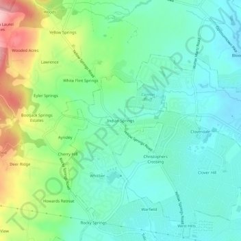
Nom : Carte topographique Indian Springs, altitude, relief.
Altitude moyenne : 143 m
Altitude minimum : 94 m
Altitude maximum : 266 m
Faire un don
Équipez-vous pour votre prochaine aventure :
En tant que Partenaire Amazon, ce site perçoit une commission sur les achats éligibles sans surcoût pour vous.