
Faire un don
Équipez-vous pour votre prochaine aventure :
En tant que Partenaire Amazon, ce site perçoit une commission sur les achats éligibles sans surcoût pour vous.
Carte topographique Salacoa
Cliquez sur la carte pour afficher l’altitude.
Faire un don
Équipez-vous pour votre prochaine aventure :
En tant que Partenaire Amazon, ce site perçoit une commission sur les achats éligibles sans surcoût pour vous.
À propos de cette carte
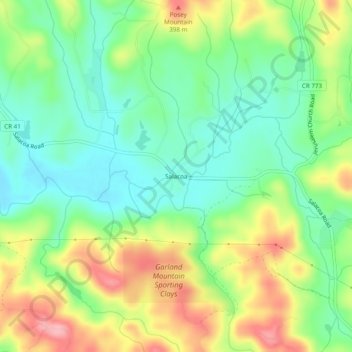
Nom : Carte topographique Salacoa, altitude, relief.
Lieu : Salacoa, Cherokee County, Georgia, United States (34.37065 -84.63132 34.41065 -84.59132)
Altitude moyenne : 326 m
Altitude minimum : 272 m
Altitude maximum : 410 m
Faire un don
Équipez-vous pour votre prochaine aventure :
En tant que Partenaire Amazon, ce site perçoit une commission sur les achats éligibles sans surcoût pour vous.
Autres cartes topographiques
Cliquez sur une carte pour visualiser sa topographie, son altitude et son relief.
Ball Ground
United States > Georgia > Cherokee County
According to the United States Census Bureau as of 2020, Ball Ground has a total area of 6.3 sq mi (16 km2), of which 0.04 sq mi (0.10 km2), or 0.63%, is water. The city's elevation averages around 1,100 ft (340 m) above sea level, ranging from just over 1,000 ft (300 m) in the valleys to around 1,200 ft (370…
Altitude moyenne : 331 m
Faire un don
Équipez-vous pour votre prochaine aventure :
En tant que Partenaire Amazon, ce site perçoit une commission sur les achats éligibles sans surcoût pour vous.
Faire un don
Équipez-vous pour votre prochaine aventure :
En tant que Partenaire Amazon, ce site perçoit une commission sur les achats éligibles sans surcoût pour vous.