
Faire un don
Équipez-vous pour votre prochaine aventure :
En tant que Partenaire Amazon, ce site perçoit une commission sur les achats éligibles sans surcoût pour vous.
Carte topographique Epworth
Cliquez sur la carte pour afficher l’altitude.
Faire un don
Équipez-vous pour votre prochaine aventure :
En tant que Partenaire Amazon, ce site perçoit une commission sur les achats éligibles sans surcoût pour vous.
À propos de cette carte
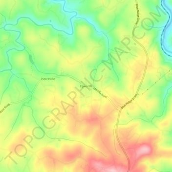
Nom : Carte topographique Epworth, altitude, relief.
Lieu : Epworth, Fannin County, Georgia, 30555, United States (34.93064 -84.40492 34.97064 -84.36492)
Altitude moyenne : 524 m
Altitude minimum : 444 m
Altitude maximum : 607 m
Faire un don
Équipez-vous pour votre prochaine aventure :
En tant que Partenaire Amazon, ce site perçoit une commission sur les achats éligibles sans surcoût pour vous.
Autres cartes topographiques
Cliquez sur une carte pour visualiser sa topographie, son altitude et son relief.
Lake Blue Ridge
United States > Georgia > Fannin County > Morganton
As part of the Blue Ridge Dam Rehabilitation project, the Tennessee Valley Authority, began slowly lowering the elevation of Blue Ridge Lake in July 2010. This rehabilitation project aimed to repair the dam penstock and to stabilize both the upstream and downstream faces of the dam. The project reduced the…
Altitude moyenne : 572 m