
Faire un don
Équipez-vous pour votre prochaine aventure :
En tant que Partenaire Amazon, ce site perçoit une commission sur les achats éligibles sans surcoût pour vous.
Carte topographique Buslavín
Cliquez sur la carte pour afficher l’altitude.
Faire un don
Équipez-vous pour votre prochaine aventure :
En tant que Partenaire Amazon, ce site perçoit une commission sur les achats éligibles sans surcoût pour vous.
À propos de cette carte
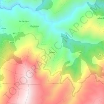
Nom : Carte topographique Buslavín, altitude, relief.
Lieu : Buslavín, Allande, Asturias, España (43.23591 -6.82044 43.27591 -6.78044)
Altitude moyenne : 564 m
Altitude minimum : 117 m
Altitude maximum : 1 087 m
Faire un don
Équipez-vous pour votre prochaine aventure :
En tant que Partenaire Amazon, ce site perçoit une commission sur les achats éligibles sans surcoût pour vous.
Autres cartes topographiques
Cliquez sur une carte pour visualiser sa topographie, son altitude et son relief.
Villar de Sapos
La aldea de Villar de Sapos se sitúa a 560 metros de altitud, en la margen izquierda del río Arganza, en la ladera sur de la sierra La Pila. Se encuentra a 18 km de Pola de Allande y tiene una población de 7 habitantes (INE 2011). Su pequeña iglesia parroquial, dedicada a Santiago, tiene en su interior un…
Altitude moyenne : 630 m