
Carte topographique Prámaro
Carte interactive
Cliquez sur la carte pour afficher l’altitude.
À propos de cette carte
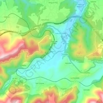
Nom : Carte topographique Prámaro, altitude, relief.
Lieu : Prámaro, Cudillero, Asturias, 33156, España (43.53492 -6.25603 43.57492 -6.21603)
Altitude moyenne : 113 m
Altitude minimum : 4 m
Altitude maximum : 293 m
Autres cartes topographiques
Cliquez sur une carte pour visualiser sa topographie, son altitude et son relief.