
Faire un don
Équipez-vous pour votre prochaine aventure :
En tant que Partenaire Amazon, ce site perçoit une commission sur les achats éligibles sans surcoût pour vous.
Carte topographique Satyamangalam
Cliquez sur la carte pour afficher l’altitude.
Faire un don
Équipez-vous pour votre prochaine aventure :
En tant que Partenaire Amazon, ce site perçoit une commission sur les achats éligibles sans surcoût pour vous.
Satyamangalam
Sathyamangalam is situated on the southern side of the Western Ghats, which extend towards the east from the Nilgiri mountains. The general topography is not flat and covered by sloping lands. Bhavani river flows at the center of the town from west to east. Agricultural wet lands are predominant on both sides of the river and dry lands are predominant on the northern side of the town. The soil mainly consists of black loam, red loam and red sand.
Faire un don
Équipez-vous pour votre prochaine aventure :
En tant que Partenaire Amazon, ce site perçoit une commission sur les achats éligibles sans surcoût pour vous.
À propos de cette carte
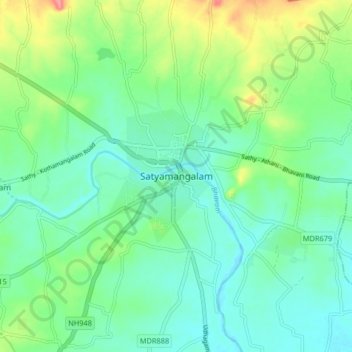
Nom : Carte topographique Satyamangalam, altitude, relief.
Altitude moyenne : 248 m
Altitude minimum : 224 m
Altitude maximum : 310 m
Faire un don
Équipez-vous pour votre prochaine aventure :
En tant que Partenaire Amazon, ce site perçoit une commission sur les achats éligibles sans surcoût pour vous.
Autres cartes topographiques
Cliquez sur une carte pour visualiser sa topographie, son altitude et son relief.