
Carte topographique Lone Butte
Carte interactive
Cliquez sur la carte pour afficher l’altitude.
Lone Butte
The northward advance of the Pacific Great Eastern Railway (PGE) rail head passed through Lone Butte in late April 1919. This construction camp had a large kitchen employing 25 cooks, of whom two received the Distinguished Conduct Medal and three the Military Medal during World War I. At an elevation of about 1,140 metres (3,740 ft), the former station was the highest on the line.
À propos de cette carte
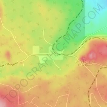
Nom : Carte topographique Lone Butte, altitude, relief.
Altitude moyenne : 1 159 m
Altitude minimum : 1 084 m
Altitude maximum : 1 225 m
Autres cartes topographiques
Cliquez sur une carte pour visualiser sa topographie, son altitude et son relief.
Sheridan Lake
Canada > British Columbia > Cariboo Regional District > Area L (Lone Butte/Interlakes)
Altitude moyenne : 1 127 m
Needa Lake
Canada > British Columbia > Cariboo Regional District > Area L (Lone Butte/Interlakes)
Altitude moyenne : 1 192 m
Horse Lake
Canada > British Columbia > Cariboo Regional District > Area L (Lone Butte/Interlakes)
Altitude moyenne : 1 097 m
Area L (Lone Butte/Interlakes)
Canada > British Columbia > Cariboo Regional District > Area L (Lone Butte/Interlakes)
Altitude moyenne : 1 147 m
Bridge Lake
Canada > British Columbia > Cariboo Regional District > Area L (Lone Butte/Interlakes)
Altitude moyenne : 1 158 m