
Carte topographique New Forest National Park
Carte interactive
Cliquez sur la carte pour afficher l’altitude.
À propos de cette carte
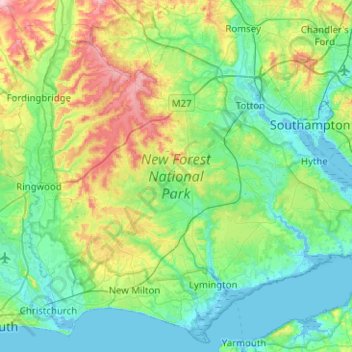
Nom : Carte topographique New Forest National Park, altitude, relief.
Lieu : New Forest National Park, Hampshire, England, United Kingdom (50.70597 -1.80348 51.00550 -1.30127)
Altitude moyenne : 34 m
Altitude minimum : -4 m
Altitude maximum : 138 m
Autres cartes topographiques
Cliquez sur une carte pour visualiser sa topographie, son altitude et son relief.
Portsmouth
United Kingdom > England > Hampshire > Portsmouth
By road, Portsmouth lies 73.5 miles (118.3 km) from Central London, 49.5 miles (79.7 km) west of Brighton, and 22.3 miles (35.9 km) east of Southampton. Portsmouth is situated primarily on Portsea Island and is the United Kingdom's only island city, although parts of it have expanded onto the mainland. Gosport…
Altitude moyenne : 28 m
Cufaude
United Kingdom > England > Hampshire > Basingstoke and Deane > Bramley
Altitude moyenne : 69 m
Basingstoke
United Kingdom > England > Hampshire > Basingstoke and Deane
Situated in a valley through the Hampshire Downs at an average elevation of 88 metres (289 ft) Basingstoke is a major interchange between Reading, Newbury, Andover, Winchester, and Alton, and lies on the natural trade route between the southwest of England and London. The area had been something of an…
Altitude moyenne : 110 m
Wolverton Townsend
United Kingdom > England > Hampshire > Basingstoke and Deane
Altitude moyenne : 106 m
Bath Meadows
United Kingdom > England > Hampshire > Test Valley > Wellow > East Wellow
Altitude moyenne : 30 m
Farnborough
United Kingdom > England > Hampshire > Rushmoor
Farnborough is located in the northeastern corner of the county of Hampshire, near the border with Surrey. The town occupies a valley setting, with the main urban area situated between the River Blackwater to the east and higher ground to the west. The topography gradually rises from the valley floor, reaching…
Altitude moyenne : 82 m
Ditcham Woods.
United Kingdom > England > Hampshire > East Hampshire > Buriton
Altitude moyenne : 136 m
Pamber Green
United Kingdom > England > Hampshire > Basingstoke and Deane > Tadley
Altitude moyenne : 85 m
Farnborough
United Kingdom > England > Hampshire > Rushmoor
Farnborough is located in the northeastern corner of the county of Hampshire, near the border with Surrey. The town occupies a valley setting, with the main urban area situated between the River Blackwater to the east and higher ground to the west. The topography gradually rises from the valley floor, reaching…
Altitude moyenne : 82 m
Basingstoke
United Kingdom > England > Hampshire > Basingstoke and Deane
Situated in a valley through the Hampshire Downs at an average elevation of 88 metres (289 ft) Basingstoke is a major interchange between Reading, Newbury, Andover, Winchester, and Alton, and lies on the natural trade route between the southwest of England and London. The area had been something of an…
Altitude moyenne : 107 m
Cold Ash Hill
United Kingdom > England > Hampshire > East Hampshire > Bramshott
Altitude moyenne : 126 m
News Wood
United Kingdom > England > Hampshire > Test Valley > King's Somborne
Altitude moyenne : 93 m
Sherborne St John
United Kingdom > England > Hampshire > Basingstoke and Deane
Altitude moyenne : 92 m
Morgaston Wood
United Kingdom > England > Hampshire > Basingstoke and Deane > Sherborne St John
Altitude moyenne : 76 m
Liphook
United Kingdom > England > Hampshire > East Hampshire
In Samuel Lewis's 1831 Topographical Dictionary of England, he referred to Liphook as a hamlet in the parish of Bramshott.
Altitude moyenne : 121 m
Rowland's Copse, Red Hill
United Kingdom > England > Hampshire > East Hampshire > Rowlands Castle
Altitude moyenne : 42 m
Ludshott Common
United Kingdom > England > Hampshire > East Hampshire > Bramshott
Altitude moyenne : 162 m
Havant Thicket
United Kingdom > England > Hampshire > East Hampshire > Rowlands Castle
Altitude moyenne : 48 m
Bramley Corner
United Kingdom > England > Hampshire > Basingstoke and Deane > Bramley
Altitude moyenne : 69 m