Géolocaliser

Carte topographique Scottish Borders

Cliquez sur la carte pour afficher l’altitude.

À propos de cette carte

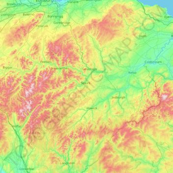
Nom : Carte topographique Scottish Borders, altitude, relief.

Lieu : Scottish Borders, Scotland, United Kingdom (55.10834 -3.53980 55.94662 -2.03321)

Altitude moyenne : 257 m

Altitude minimum : 0 m

Altitude maximum : 836 m

Autres cartes topographiques

Cliquez sur une carte pour visualiser sa topographie, son altitude et son relief.

Glasgow

United Kingdom > Scotland > Glasgow City

Glasgow itself was reputed to have been founded by the Christian missionary Saint Mungo in the 6th century. He established a church on the Molendinar Burn, where the present Glasgow Cathedral stands, and in the following years Glasgow became a religious centre. Glasgow grew over the following centuries. The…

Altitude moyenne : 128 m

Aviemore

United Kingdom > Scotland > Highland

Altitude moyenne : 331 m

Edinburgh

United Kingdom > Scotland > Edinburgh

Some have called Edinburgh the Athens of the North for a variety of reasons. The earliest comparison between the two cities showed that they had a similar topography, with the Castle Rock of Edinburgh performing a similar role to the Athenian Acropolis. Both of them had flatter, fertile agricultural land…

Altitude moyenne : 104 m

Aberdeen

United Kingdom > Scotland > Aberdeen

Two weather stations collect climate data for the area, Aberdeen/Dyce Airport, and Craibstone. Both are about 4 1⁄2 miles (7 km) to the north west of the city centre, and given that they are in close proximity to each other, exhibit very similar climatic regimes. Dyce tends to have marginally warmer daytime…

Altitude moyenne : 52 m

Glencoe

United Kingdom > Scotland > Highland

Altitude moyenne : 114 m

Scottish Highlands

United Kingdom > Scotland > Highland

The entire region was covered by ice sheets during the Pleistocene ice ages, save perhaps for a few nunataks. The complex geomorphology includes incised valleys and lochs carved by the action of mountain streams and ice, and a topography of irregularly distributed mountains whose summits have similar heights…

Altitude moyenne : 907 m

Kilmacolm

United Kingdom > Scotland > Inverclyde

Altitude moyenne : 114 m

Dundee

United Kingdom > Scotland > Dundee City

Dundee sits on the north bank of the Firth of Tay on the eastern, North Sea Coast of Scotland. The city lies 36.1 miles (58 km) NNE of Edinburgh and 360.6 miles (580 km) NNW of London. The built-up area occupies a roughly rectangular shape 8.3 miles (13 km) long by 2.5 miles (4 km) wide, aligned in an east to…

Altitude moyenne : 82 m

Falkirk

United Kingdom > Scotland > Falkirk

Falkirk is located in an area of undulating topography between the Slamannan Plateau and the upper reaches of the Firth of Forth. The area to the north of Falkirk is part of the floodplain of the River Carron. Two tributaries of the River Carron - the East Burn and the West Burn flow through the town and form…

Altitude moyenne : 69 m

Inverness

United Kingdom > Scotland > Highland

Altitude moyenne : 163 m

Fort William

United Kingdom > Scotland > Highland

Fort William has an oceanic climate (Cfb) with moderate, but generally cool, temperatures and abundant precipitation. In the towns immediate vicinity, there are significant variations in elevation, which leads to some uninhabited areas near the town having a subpolar oceanic climate (Cfc), or, at the absolute…

Altitude moyenne : 122 m

Port Lamont

United Kingdom > Scotland > Argyll and Bute

Altitude moyenne : 42 m

Kintore

United Kingdom > Scotland > Aberdeenshire

Altitude moyenne : 88 m

Roslin

United Kingdom > Scotland > Midlothian

Altitude moyenne : 155 m

Carluke

United Kingdom > Scotland > South Lanarkshire

Altitude moyenne : 191 m

Pitlochry

United Kingdom > Scotland > Perth and Kinross

Altitude moyenne : 276 m

Ben Nevis

United Kingdom > Scotland > Highland

Ben Nevis has a highland (alpine) maritime (oceanic) polar climate (ET climate in the Köppen classification). Ben Nevis's elevation, maritime location and topography frequently lead to cool and cloudy weather conditions, which can pose a danger to ill-equipped walkers. According to the observations carried…

Altitude moyenne : 912 m

Longbar

United Kingdom > Scotland > North Ayrshire > Kilbirnie

Altitude moyenne : 61 m

Laurencekirk

United Kingdom > Scotland > Aberdeenshire

Altitude moyenne : 105 m

Papa Stour

United Kingdom > Scotland > Shetland

Altitude moyenne : 9 m

Mugdrum

United Kingdom > Scotland > Fife > Newburgh

Altitude moyenne : 51 m

Rubha nam Bùthan

United Kingdom > Scotland

Altitude moyenne : 15 m

East Whitburn

United Kingdom > Scotland > West Lothian

Altitude moyenne : 174 m

Banchory

United Kingdom > Scotland > Aberdeenshire

Altitude moyenne : 118 m

Cornhill

United Kingdom > Scotland > Aberdeenshire

Altitude moyenne : 114 m

Berryhill

United Kingdom > Scotland > Angus > Fowlis Easter

Altitude moyenne : 115 m

Gateside

United Kingdom > Scotland > North Ayrshire

Altitude moyenne : 110 m

Torroble

United Kingdom > Scotland > Highland

Altitude moyenne : 144 m

Hardgate

United Kingdom > Scotland > West Dunbartonshire

Altitude moyenne : 90 m

Fogwatt

United Kingdom > Scotland > Moray

Altitude moyenne : 110 m

Cuminestown

United Kingdom > Scotland > Aberdeenshire

Altitude moyenne : 119 m

Strathbogie

United Kingdom > Scotland > Aberdeenshire > Huntly

Altitude moyenne : 239 m

Edzell

United Kingdom > Scotland > Angus

Altitude moyenne : 69 m

Coatbridge

United Kingdom > Scotland > North Lanarkshire

The topography of Coatbridge was an important feature in the town's development during the Industrial Revolution. Coatbridge rests 60 metres below the "Slamannan plateau" and neighbouring Airdrie sits on its edge. The low-lying flat ground of Coatbridge was a vital factor in the siting of the town's blast…

Altitude moyenne : 100 m

Fearnan

United Kingdom > Scotland > Perth and Kinross

Altitude moyenne : 233 m

Scone

United Kingdom > Scotland > Perth and Kinross

Altitude moyenne : 81 m

Aberlour

United Kingdom > Scotland > Moray

According to the 1846 A Topographical Dictionary of Scotland, "This parish, formerly called Skirdustan, signifying, in the Gaelic tongue, 'the division of Dustan', its tutelary saint, derived its present name from its situation at the mouth of a noisy burn, which discharges itself into the river Spey."

Altitude moyenne : 160 m

Portlethen

United Kingdom > Scotland > Aberdeenshire

Altitude moyenne : 60 m

Penicuik

United Kingdom > Scotland > Midlothian

Altitude moyenne : 247 m

Advie

United Kingdom > Scotland > Highland

Altitude moyenne : 228 m

Craigburn

United Kingdom > Scotland > Perth and Kinross > Rait

Altitude moyenne : 77 m

Glen Lyon

United Kingdom > Scotland > Perth and Kinross

Altitude moyenne : 463 m

Aberfeldy

United Kingdom > Scotland > Perth and Kinross

Altitude moyenne : 304 m

Muirhead

United Kingdom > Scotland > North Lanarkshire

Altitude moyenne : 80 m

Inchcolm

United Kingdom > Scotland > Fife

Altitude moyenne : 1 m

Kellas

United Kingdom > Scotland > Angus

Altitude moyenne : 95 m

St Andrews

United Kingdom > Scotland > Fife

Altitude moyenne : 38 m

Orphir

United Kingdom > Scotland > Orkney Islands

Altitude moyenne : 64 m

Lyness

United Kingdom > Scotland > Orkney Islands

Altitude moyenne : 28 m

Invergordon

United Kingdom > Scotland > Highland

Altitude moyenne : 24 m

Glasphein

United Kingdom > Scotland > Highland > Glendale

Altitude moyenne : 104 m

Ben Stack

United Kingdom > Scotland > Highland

Altitude moyenne : 274 m

Paisley

United Kingdom > Scotland > Renfrewshire

Altitude moyenne : 33 m

Gartloch

United Kingdom > Scotland > Glasgow City

Altitude moyenne : 85 m

Doll

United Kingdom > Scotland > Highland

Altitude moyenne : 28 m

Armadale

United Kingdom > Scotland > Highland

Altitude moyenne : 46 m

Greens

United Kingdom > Scotland > Aberdeenshire

Altitude moyenne : 122 m

Turriff

United Kingdom > Scotland > Aberdeenshire

Altitude moyenne : 91 m

Kirkton of Deskford

United Kingdom > Scotland > Moray

Altitude moyenne : 131 m

Preston

United Kingdom > Scotland > Scottish Borders

Altitude moyenne : 132 m

Kirkmuirhill

United Kingdom > Scotland > South Lanarkshire

Altitude moyenne : 195 m

Callander

United Kingdom > Scotland > Stirling

Altitude moyenne : 125 m

Lintmill Burnside

United Kingdom > Scotland > Moray > Lintmill

Altitude moyenne : 62 m

Lesmahagow

United Kingdom > Scotland > South Lanarkshire

Altitude moyenne : 226 m

Strathblane

United Kingdom > Scotland > Stirling

Altitude moyenne : 185 m

Dechmont

United Kingdom > Scotland > West Lothian

Altitude moyenne : 155 m

Twatt

United Kingdom > Scotland > Shetland

Altitude moyenne : 35 m

Buckhaven

United Kingdom > Scotland > Fife

Altitude moyenne : 21 m

Lost

United Kingdom > Scotland > Aberdeenshire > Bellabeg

Altitude moyenne : 373 m

Rutherglen

United Kingdom > Scotland > South Lanarkshire

Altitude moyenne : 55 m

Dalmellington

United Kingdom > Scotland > East Ayrshire

Altitude moyenne : 285 m

Rutherglen

United Kingdom > Scotland > South Lanarkshire

Altitude moyenne : 55 m

Annan

United Kingdom > Scotland > Dumfries and Galloway

Altitude moyenne : 26 m

Stonehouse

United Kingdom > Scotland > South Lanarkshire

Altitude moyenne : 166 m

Livingston

United Kingdom > Scotland > West Lothian

Altitude moyenne : 158 m

Lossiemouth

United Kingdom > Scotland > Moray

Altitude moyenne : 3 m

Bogknowe

United Kingdom > Scotland > Dumfries and Galloway

Altitude moyenne : 116 m

Bonnyrigg

United Kingdom > Scotland > Midlothian

Altitude moyenne : 114 m

Knock Hill

United Kingdom > Scotland > Fife > Newport-on-Tay

Altitude moyenne : 44 m

Clachnaben

United Kingdom > Scotland > Aberdeenshire

Altitude moyenne : 435 m

Teviothead

United Kingdom > Scotland > Scottish Borders

Altitude moyenne : 252 m

Bowden

United Kingdom > Scotland > Scottish Borders

Altitude moyenne : 181 m

Fairy Pools

United Kingdom > Scotland > Highland

Altitude moyenne : 278 m

Mauchline

United Kingdom > Scotland > East Ayrshire

Altitude moyenne : 125 m

Wood Head

United Kingdom > Scotland > Scottish Borders

Altitude moyenne : 129 m

Glenprosen Lodge

United Kingdom > Scotland > Angus

Altitude moyenne : 411 m

Lhanbryde

United Kingdom > Scotland > Moray

Altitude moyenne : 39 m

Dundee

United Kingdom > Scotland > Dundee City

Dundee sits on the north bank of the Firth of Tay on the eastern, North Sea Coast of Scotland. The city lies 36.1 miles (58 km) NNE of Edinburgh and 360.6 miles (580 km) NNW of London. The built-up area occupies a roughly rectangular shape 8.3 miles (13 km) long by 2.5 miles (4 km) wide, aligned in an east to…

Altitude moyenne : 83 m

Traquair

United Kingdom > Scotland > Scottish Borders

Altitude moyenne : 247 m