
Faire un don
Équipez-vous pour votre prochaine aventure :
En tant que Partenaire Amazon, ce site perçoit une commission sur les achats éligibles sans surcoût pour vous.
Carte topographique Todmorden
Cliquez sur la carte pour afficher l’altitude.
Équipez-vous pour votre prochaine aventure :
En tant que Partenaire Amazon, ce site perçoit une commission sur les achats éligibles sans surcoût pour vous.
Todmorden
Todmorden Town Hall, which was designed in the Neo-Classical style, dominates the centre of the town. The building straddles the Walsden Water, a tributary of the River Calder, and was situated in both Lancashire and Yorkshire until the administrative county boundary was moved on 1 January 1888. Designed by John Gibson of Westminster, this imposing building has a northern end which is semi-circular. One interesting external feature of the town hall is the pediment to the front elevation, which reflects the fact that it straddled the boundary as it depicts the main industries of the two counties. The fine carved stonework has two central female figures on a pedestal. The left-hand sculpture represents Lancashire (cotton spinning and weaving industries), and the right-hand one Yorkshire (wool manufacturing, engineering and agriculture).
Faire un don
Équipez-vous pour votre prochaine aventure :
En tant que Partenaire Amazon, ce site perçoit une commission sur les achats éligibles sans surcoût pour vous.
À propos de cette carte
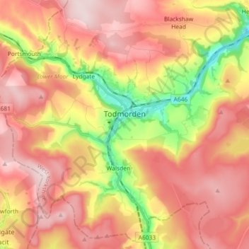
Nom : Carte topographique Todmorden, altitude, relief.
Lieu : Todmorden, Calderdale, West Yorkshire, England, United Kingdom (53.67015 -2.17329 53.74966 -2.02964)
Altitude moyenne : 311 m
Altitude minimum : 104 m
Altitude maximum : 456 m
Faire un don
Équipez-vous pour votre prochaine aventure :
En tant que Partenaire Amazon, ce site perçoit une commission sur les achats éligibles sans surcoût pour vous.
Autres cartes topographiques
Cliquez sur une carte pour visualiser sa topographie, son altitude et son relief.
Halifax
United Kingdom > England > Calderdale
Topographically, Halifax is located in the south-eastern corner of the moorland region called the South Pennines. Halifax is situated about 4 miles (6 km) from the M62 motorway, close to Bradford and Huddersfield. The A641 road links the town with Brighouse, Bradford and Huddersfield. The Hebble Brook joins…
Altitude moyenne : 195 m
Halifax
United Kingdom > England > Calderdale
Topographically, Halifax is located in the south-eastern foothills of the moorland region called the South Pennines. Halifax is situated about 4 miles (6 km) from the M62 motorway, close to Bradford and Huddersfield. The A641 road links the town with Brighouse, Bradford and Huddersfield. The Hebble Brook joins…
Altitude moyenne : 196 m
Faire un don
Équipez-vous pour votre prochaine aventure :
En tant que Partenaire Amazon, ce site perçoit une commission sur les achats éligibles sans surcoût pour vous.
Faire un don
Équipez-vous pour votre prochaine aventure :
En tant que Partenaire Amazon, ce site perçoit une commission sur les achats éligibles sans surcoût pour vous.
Faire un don
Équipez-vous pour votre prochaine aventure :
En tant que Partenaire Amazon, ce site perçoit une commission sur les achats éligibles sans surcoût pour vous.
Gaddings Dam
United Kingdom > England > Calderdale > Todmorden > Walsden
Gaddings Dam is a locally owned reservoir near to Todmorden in West Yorkshire, England. The dam was built to power water mills in the Todmorden area, being superseded by steam power and left redundant. It is notable for having a sandy beach at the north-eastern side which attracts people to it during the…
Altitude moyenne : 283 m
Faire un don
Équipez-vous pour votre prochaine aventure :
En tant que Partenaire Amazon, ce site perçoit une commission sur les achats éligibles sans surcoût pour vous.
Halifax
United Kingdom > England > Calderdale
Topographically, Halifax is located in the south-eastern foothills of the moorland region called the South Pennines. Halifax is situated about 4 miles (6 km) from the M62 motorway, close to Bradford and Huddersfield. The A641 road links the town with Brighouse, Bradford and Huddersfield. The Hebble Brook joins…
Altitude moyenne : 196 m
Faire un don
Équipez-vous pour votre prochaine aventure :
En tant que Partenaire Amazon, ce site perçoit une commission sur les achats éligibles sans surcoût pour vous.
Faire un don
Équipez-vous pour votre prochaine aventure :
En tant que Partenaire Amazon, ce site perçoit une commission sur les achats éligibles sans surcoût pour vous.
Ragby Plantation
United Kingdom > England > Calderdale > Todmorden > Walsden > Bottoms
Altitude moyenne : 293 m
Faire un don
Équipez-vous pour votre prochaine aventure :
En tant que Partenaire Amazon, ce site perçoit une commission sur les achats éligibles sans surcoût pour vous.
Faire un don
Équipez-vous pour votre prochaine aventure :
En tant que Partenaire Amazon, ce site perçoit une commission sur les achats éligibles sans surcoût pour vous.
Faire un don
Équipez-vous pour votre prochaine aventure :
En tant que Partenaire Amazon, ce site perçoit une commission sur les achats éligibles sans surcoût pour vous.
Calder & Hebble Navigation Halifax Cut
United Kingdom > England > Calderdale > Skircoat Green
Altitude moyenne : 136 m
Faire un don
Équipez-vous pour votre prochaine aventure :
En tant que Partenaire Amazon, ce site perçoit une commission sur les achats éligibles sans surcoût pour vous.
Faire un don
Équipez-vous pour votre prochaine aventure :
En tant que Partenaire Amazon, ce site perçoit une commission sur les achats éligibles sans surcoût pour vous.
Faire un don
Équipez-vous pour votre prochaine aventure :
En tant que Partenaire Amazon, ce site perçoit une commission sur les achats éligibles sans surcoût pour vous.
Faire un don
Équipez-vous pour votre prochaine aventure :
En tant que Partenaire Amazon, ce site perçoit une commission sur les achats éligibles sans surcoût pour vous.
Faire un don
Équipez-vous pour votre prochaine aventure :
En tant que Partenaire Amazon, ce site perçoit une commission sur les achats éligibles sans surcoût pour vous.
Faire un don
Équipez-vous pour votre prochaine aventure :
En tant que Partenaire Amazon, ce site perçoit une commission sur les achats éligibles sans surcoût pour vous.
Faire un don
Équipez-vous pour votre prochaine aventure :
En tant que Partenaire Amazon, ce site perçoit une commission sur les achats éligibles sans surcoût pour vous.