
Faire un don
Équipez-vous pour votre prochaine aventure :
En tant que Partenaire Amazon, ce site perçoit une commission sur les achats éligibles sans surcoût pour vous.
Carte topographique Jelebu
Cliquez sur la carte pour afficher l’altitude.
Faire un don
Équipez-vous pour votre prochaine aventure :
En tant que Partenaire Amazon, ce site perçoit une commission sur les achats éligibles sans surcoût pour vous.
Jelebu
Amongst the seven districts of Negeri Sembilan, Jelebu is the most mountainous topographically as the Titiwangsa Mountains, the longest mountain range in Malaysia, transverses through the district. As a result, most of its terrain are dominated by forested undulating hills and mountain peaks. The Titiwangsa Mountains open up into a 77 sq km (30 sq mi) wide intermontane basin encompassing the central part of the district, of which major settlements like Kuala Klawang and Titi are situated in. The eastern and southern parts of the district are relatively flat, where agriculture flourished. Jelebu District is home to Negeri Sembilan's tallest mountain, Mount Besar Hantu (1,462 m), near the border with Pahang. The other significant peak within the district is Mount Telapak Buruk (1,193 m) on the border with Seremban District. The Pasoh Caves, the southernmost limestone cave complex in Malaysia, is also located in Jelebu. The Pasoh Caves are also known for being the first Paleolithic site in southern Peninsular Malaysia, as well as the southernmost in Malaysia.
Faire un don
Équipez-vous pour votre prochaine aventure :
En tant que Partenaire Amazon, ce site perçoit une commission sur les achats éligibles sans surcoût pour vous.
À propos de cette carte
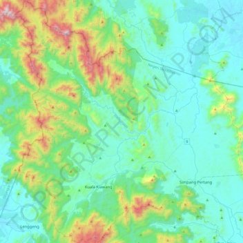
Nom : Carte topographique Jelebu, altitude, relief.
Lieu : Jelebu, Negeri Sembilan, Malaysia (2.82976 101.91385 3.29033 102.35321)
Altitude moyenne : 307 m
Altitude minimum : 35 m
Altitude maximum : 1 435 m
Faire un don
Équipez-vous pour votre prochaine aventure :
En tant que Partenaire Amazon, ce site perçoit une commission sur les achats éligibles sans surcoût pour vous.
Autres cartes topographiques
Cliquez sur une carte pour visualiser sa topographie, son altitude et son relief.
Faire un don
Équipez-vous pour votre prochaine aventure :
En tant que Partenaire Amazon, ce site perçoit une commission sur les achats éligibles sans surcoût pour vous.
Faire un don
Équipez-vous pour votre prochaine aventure :
En tant que Partenaire Amazon, ce site perçoit une commission sur les achats éligibles sans surcoût pour vous.
Faire un don
Équipez-vous pour votre prochaine aventure :
En tant que Partenaire Amazon, ce site perçoit une commission sur les achats éligibles sans surcoût pour vous.