
Faire un don
Équipez-vous pour votre prochaine aventure :
En tant que Partenaire Amazon, ce site perçoit une commission sur les achats éligibles sans surcoût pour vous.
Carte topographique Port Dickson
Cliquez sur la carte pour afficher l’altitude.
Faire un don
Équipez-vous pour votre prochaine aventure :
En tant que Partenaire Amazon, ce site perçoit une commission sur les achats éligibles sans surcoût pour vous.
À propos de cette carte
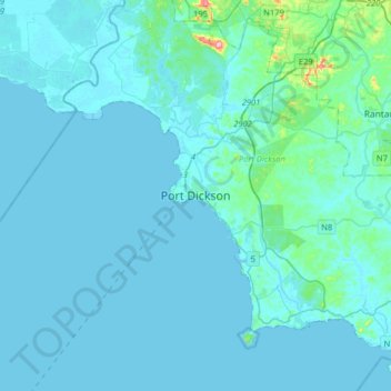
Nom : Carte topographique Port Dickson, altitude, relief.
Lieu : Port Dickson, Negeri Sembilan, 71000, Malaysia (2.36289 101.63451 2.68289 101.95451)
Altitude moyenne : 12 m
Altitude minimum : -1 m
Altitude maximum : 240 m
Faire un don
Équipez-vous pour votre prochaine aventure :
En tant que Partenaire Amazon, ce site perçoit une commission sur les achats éligibles sans surcoût pour vous.
Autres cartes topographiques
Cliquez sur une carte pour visualiser sa topographie, son altitude et son relief.
Jelebu
Amongst the seven districts of Negeri Sembilan, Jelebu is the most mountainous topographically as the Titiwangsa Mountains, the longest mountain range in Malaysia, transverses through the district. As a result, most of its terrain are dominated by forested undulating hills and mountain peaks. The Titiwangsa…
Altitude moyenne : 307 m
Faire un don
Équipez-vous pour votre prochaine aventure :
En tant que Partenaire Amazon, ce site perçoit une commission sur les achats éligibles sans surcoût pour vous.