
Faire un don
Équipez-vous pour votre prochaine aventure :
En tant que Partenaire Amazon, ce site perçoit une commission sur les achats éligibles sans surcoût pour vous.
Carte topographique Pahalgam
Cliquez sur la carte pour afficher l’altitude.
Faire un don
Équipez-vous pour votre prochaine aventure :
En tant que Partenaire Amazon, ce site perçoit une commission sur les achats éligibles sans surcoût pour vous.
Pahalgam
Pahalgam (Hindustani pronunciation: [pɛhɛlɡaːm]), known as Pahalgom (Kashmiri pronunciation: [pəhəlʲɡoːm]; lit. 'village of shepherds' in Kashmiri) is a town and a notified area committee, near Anantnag city in the Anantnag district of the Indian-administered union territory of Jammu and Kashmir. It is a popular tourist destination and hill station. Its lush green meadows and pristine waters attract thousands of tourists from all over the world each year. It is located 45 kilometres (28 mi) from Anantnag on the banks of Lidder River at an altitude of 7,200 feet (2,200 m). Pahalgam is the headquarters of one of the eleven tehsils of Anantnag district.
Faire un don
Équipez-vous pour votre prochaine aventure :
En tant que Partenaire Amazon, ce site perçoit une commission sur les achats éligibles sans surcoût pour vous.
À propos de cette carte
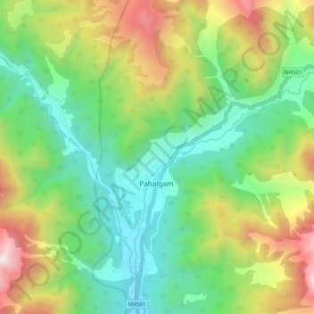
Nom : Carte topographique Pahalgam, altitude, relief.
Lieu : Pahalgam, Anantnag district, Jammu and Kashmir, 192126, India (33.99220 75.28265 34.07220 75.36265)
Altitude moyenne : 2 700 m
Altitude minimum : 2 082 m
Altitude maximum : 3 909 m
Faire un don
Équipez-vous pour votre prochaine aventure :
En tant que Partenaire Amazon, ce site perçoit une commission sur les achats éligibles sans surcoût pour vous.
Autres cartes topographiques
Cliquez sur une carte pour visualiser sa topographie, son altitude et son relief.