
Carte topographique Sundersar
Cliquez sur la carte pour afficher l’altitude.
À propos de cette carte
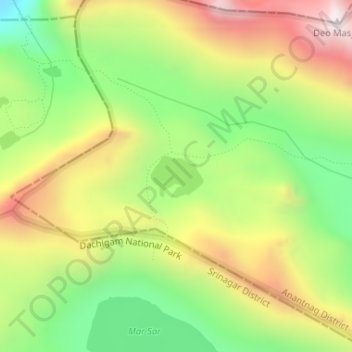
Nom : Carte topographique Sundersar, altitude, relief.
Altitude moyenne : 3 989 m
Altitude minimum : 3 586 m
Altitude maximum : 4 460 m
Autres cartes topographiques
Cliquez sur une carte pour visualiser sa topographie, son altitude et son relief.
Amarnath Cave Temple
India > Jammu and Kashmir > Pahalgam
The Shiva Lingam at the shrine is a Swayambhu lingam. The lingam is a natural stalagmite formation located at the Amarnath Mountain which has a peak of 5,186 metres (17,014 ft), and inside a 40 m (130 ft) high cave at an elevation of 3,888 m (12,756 ft). The stalagmite is formed due to the freezing of water…
Altitude moyenne : 4 325 m
Pahalgam
India > Jammu and Kashmir > Pahalgam
Pahalgam (Hindustani pronunciation: [pɛhɛlɡaːm]), known as Pahalgom (Kashmiri pronunciation: [pəhəlʲɡoːm]; lit. 'village of shepherds' in Kashmiri) is a town and a notified area committee, near Anantnag city in the Anantnag district of the Indian-administered union territory of Jammu and Kashmir. It…
Altitude moyenne : 2 700 m