
Carte topographique Gwādar
Carte interactive
Cliquez sur la carte pour afficher l’altitude.
À propos de cette carte
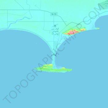
Nom : Carte topographique Gwādar, altitude, relief.
Lieu : Gwādar, Gwadar District, Balochistan, Pakistan (24.98798 62.16546 25.30798 62.48546)
Altitude moyenne : 6 m
Altitude minimum : -1 m
Altitude maximum : 345 m
Gwadar is situated on the southwestern Arabian Sea coast of Pakistan in Gwadar District of Balochistan province. Like Ormara further east, Gwadar is situated on a natural hammerhead-shaped tombolo peninsula forming two almost perfect, but naturally curved, semicircular bays on either side. The city is situated on a narrow and sandy 12 km-long (7 mi) isthmus which connects the Pakistani coast to rocky outcroppings in the Arabian sea known as the Gwadar Promontory, or Koh-e-Batil, which reach an elevation of 150 m (480 ft) and extend 11 km (7 mi) east to west with a breadth of 1.5 km (1 mi). The 240 m (800 ft) wide isthmus upon which Gwadar is located separates the two almost perfect semicircular bays from one another. The western bay is known as the Paddi Zirr, and is generally shallow with an average depth of 3.7 m (12 ft), and a maximum depth of 9.1 m (30 ft). To the east of the isthmus is the deepwater Demi Zirr harbour, where the Gwadar Port was built.
Autres cartes topographiques
Cliquez sur une carte pour visualiser sa topographie, son altitude et son relief.
Hub
Pakistan > Balochistan > Hub District
Hub, Hub Tehsil, Hub District, Qalat Division, Balochistan, 90250, Pakistan
Altitude moyenne : 55 m
Quetta City Tehsil
Pakistan > Balochistan > Quetta District
Quetta City Tehsil, Quetta District, Quetta Division, Balochistan, Pakistan
Altitude moyenne : 1 981 m
Kanar
Pakistan > Balochistan > Lasbela District
Kanar, Lasbela District, Balochistan, Pakistan
Altitude moyenne : 286 m
Khuzdar
Khuzdar, Khuzdar District, Balochistan, 89100, Pakistan
Altitude moyenne : 1 417 m
Quetta
Pakistan > Balochistan > Quetta
Quetta, Mastung District, Balochistan, 87300, Pakistan
Altitude moyenne : 1 968 m
Lakhani
Pakistan > Balochistan > Lakhani
Lakhani, Khuzdar District, Balochistan, Pakistan
Altitude moyenne : 1 177 m
Loralai District
Loralai District, Balochistan, Pakistan
Altitude moyenne : 1 416 m
Qilla Abdullah
Pakistan > Balochistan > Qilla Abdullah
Qilla Abdullah, Qila Abdullāh District, Balochistan, 86200, Pakistan
Altitude moyenne : 1 591 m
Hanna Lake
Pakistan > Balochistan > Quetta
Hanna Lake, Quetta Road, Cantonment, Quetta, Ziārat District, Balochistan, 87300, Pakistan
Altitude moyenne : 1 957 m
Loralai
Pakistan > Balochistan > Loralai
Loralai, Loralai District, Balochistan, 84800, Pakistan
Altitude moyenne : 1 433 m