
Faire un don
Équipez-vous pour votre prochaine aventure :
En tant que Partenaire Amazon, ce site perçoit une commission sur les achats éligibles sans surcoût pour vous.
Carte topographique Dallas
Cliquez sur la carte pour afficher l’altitude.
Faire un don
Équipez-vous pour votre prochaine aventure :
En tant que Partenaire Amazon, ce site perçoit une commission sur les achats éligibles sans surcoût pour vous.
Dallas
On April 4, 1977, near the site marker for the Battle of New Hope Church, the forced landing of Southern Airways Flight 242 occurred. The passenger jetliner, a McDonnell Douglas DC-9 with 81 passengers and 4 crew members, was flying from Northwest Alabama Regional Airport to Atlanta Municipal Airport. Upon descending in altitude to prepare for landing in Atlanta, the jetliner started to fly through an intense thunderstorm near Rome, Georgia. Because of the extreme amounts of water and hail that were ingested by the jet's engines, both of the Pratt & Whitney JT8D-7A turbojet engines were damaged and underwent flameout. With the engines unable to restart, the flight's crew began gliding in hopes of reaching a nearby airport. Upon finding out that there were no nearby airports to perform a landing, the crew found a straight section of rural road in Dallas, Georgia to try and land. As the plane began to land, it clipped a gas station, convenience store, and other buildings, resulting in the plane to lose control of landing and ultimately crash, resulting in hull loss. Both pilots and 61 passengers were killed by impact forces and fire. Nine people on the ground were also killed.
Faire un don
Équipez-vous pour votre prochaine aventure :
En tant que Partenaire Amazon, ce site perçoit une commission sur les achats éligibles sans surcoût pour vous.
À propos de cette carte
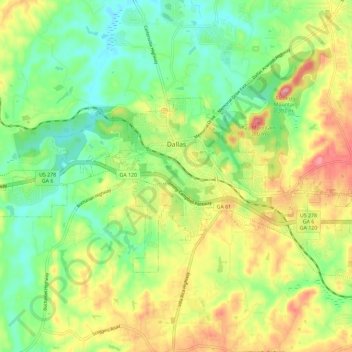
Nom : Carte topographique Dallas, altitude, relief.
Lieu : Dallas, Paulding County, Georgia, United States (33.88875 -84.89893 33.94127 -84.78327)
Altitude moyenne : 307 m
Altitude minimum : 252 m
Altitude maximum : 386 m
Faire un don
Équipez-vous pour votre prochaine aventure :
En tant que Partenaire Amazon, ce site perçoit une commission sur les achats éligibles sans surcoût pour vous.
Autres cartes topographiques
Cliquez sur une carte pour visualiser sa topographie, son altitude et son relief.
Faire un don
Équipez-vous pour votre prochaine aventure :
En tant que Partenaire Amazon, ce site perçoit une commission sur les achats éligibles sans surcoût pour vous.