
Faire un don
Équipez-vous pour votre prochaine aventure :
En tant que Partenaire Amazon, ce site perçoit une commission sur les achats éligibles sans surcoût pour vous.
Carte topographique Ray Mountain
Cliquez sur la carte pour afficher l’altitude.
Faire un don
Équipez-vous pour votre prochaine aventure :
En tant que Partenaire Amazon, ce site perçoit une commission sur les achats éligibles sans surcoût pour vous.
À propos de cette carte
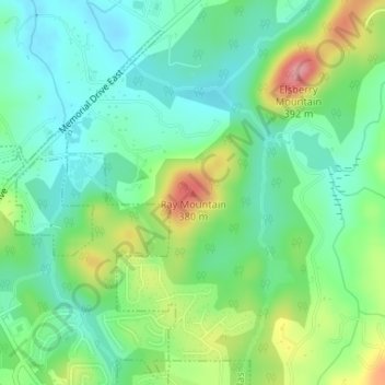
Nom : Carte topographique Ray Mountain, altitude, relief.
Lieu : Ray Mountain, Paulding County, Georgia, 30132, United States (33.92978 -84.81388 33.92988 -84.81378)
Altitude moyenne : 306 m
Altitude minimum : 267 m
Altitude maximum : 386 m
Faire un don
Équipez-vous pour votre prochaine aventure :
En tant que Partenaire Amazon, ce site perçoit une commission sur les achats éligibles sans surcoût pour vous.
Autres cartes topographiques
Cliquez sur une carte pour visualiser sa topographie, son altitude et son relief.
Dallas
United States > Georgia > Paulding County
On April 4, 1977, near the site marker for the Battle of New Hope Church, the forced landing of Southern Airways Flight 242 occurred. The passenger jetliner, a McDonnell Douglas DC-9 with 81 passengers and 4 crew members, was flying from Northwest Alabama Regional Airport to Atlanta Municipal Airport. Upon…
Altitude moyenne : 307 m
Faire un don
Équipez-vous pour votre prochaine aventure :
En tant que Partenaire Amazon, ce site perçoit une commission sur les achats éligibles sans surcoût pour vous.
Dallas
United States > Georgia > Paulding County
On April 4, 1977, near the site marker for the Battle of New Hope Church, the forced landing of Southern Airways Flight 242 occurred. The passenger jetliner, a McDonnell Douglas DC-9 with 81 passengers and 4 crew members, was flying from Northwest Alabama Regional Airport to Atlanta Municipal Airport. Upon…
Altitude moyenne : 307 m