
Carte topographique Clearview
Cliquez sur la carte pour afficher l’altitude.
À propos de cette carte
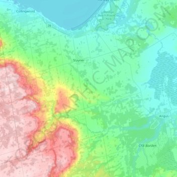
Nom : Carte topographique Clearview, altitude, relief.
Lieu : Clearview, Simcoe County, Central Ontario, Ontario, Canada (44.25342 -80.28167 44.48885 -79.86119)
Altitude moyenne : 275 m
Altitude minimum : 173 m
Altitude maximum : 541 m
Autres cartes topographiques
Cliquez sur une carte pour visualiser sa topographie, son altitude et son relief.
Penatanguishene Memorial Park
Canada > Ontario > Simcoe County > Penetanguishene
Altitude moyenne : 210 m
Mara Provincial Park
Canada > Ontario > Simcoe County > Ramara Township > Atherley
Altitude moyenne : 220 m
Beckwith Island
Canada > Ontario > Simcoe County
The island's highest elevation is 226 meters (741 feet) above sea level. Like its populated neighbour Christian Island to the west, and Hope Island to the northwest, the uninhabited island is part of an Ojibwa reserve. On the mainland, Cedar Point lies directly south of the island and Thunder Beach is located…
Altitude moyenne : 185 m
Waubashene Beaches Provincial Park
Canada > Ontario > Simcoe County > Tay > Waubaushene
Altitude moyenne : 189 m
Springhurst Beach
Canada > Ontario > Simcoe County > Wasaga Beach > Springhurst Beach
Altitude moyenne : 184 m
Wasaga Beach Provincial Park
Canada > Ontario > Simcoe County > Wasaga Beach
The Town of Wasaga Beach covers an area of 61.13 square kilometres (23.60 sq mi) comprised predominantly of sand and loamy sand that exhibit excessive to good drainage and irregular to moderately sloping topography. The poor soil quality makes it difficult to sustain lush lawns in the town. The Canada Land…
Altitude moyenne : 188 m
West Holland River (old)
Canada > Ontario > Simcoe County > Bradford West Gwillimbury
Altitude moyenne : 222 m