
Carte topographique Hoddesdon
Cliquez sur la carte pour afficher l’altitude.
À propos de cette carte
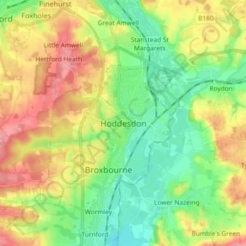
Nom : Carte topographique Hoddesdon, altitude, relief.
Altitude moyenne : 54 m
Altitude minimum : 17 m
Altitude maximum : 105 m
Autres cartes topographiques
Cliquez sur une carte pour visualiser sa topographie, son altitude et son relief.
St Albans
United Kingdom > England > Hertfordshire > St Albans
St Albans was an ancient borough created following the dissolution of the monastery in 1539. It consisted of the ancient parish of St Albans (also known as the Abbey parish) and parts of St Michael and St Peter. The municipal corporation was reformed by the Municipal Corporations Act 1835 and the boundary was…
Altitude moyenne : 100 m
Knebworth Country Park
United Kingdom > England > Hertfordshire > North Hertfordshire > Knebworth
Altitude moyenne : 116 m
Croxley Green
United Kingdom > England > Hertfordshire > Three Rivers > Rickmansworth
Altitude moyenne : 67 m
Sawbridgeworth
United Kingdom > England > Hertfordshire > East Hertfordshire > Sawbridgeworth
Altitude moyenne : 67 m
Bishop's Stortford
United Kingdom > England > Hertfordshire > East Hertfordshire
Stortford, along with the rest of Britain, has a temperate maritime climate, with cool summers and mild winters. The nearest weather station for which averages and extremes are available is Stansted Airport, about 2+1⁄2 miles (4 kilometres) due east of Stortford's town centre. Located at an elevation of over…
Altitude moyenne : 83 m
St Albans
United Kingdom > England > Hertfordshire
The borough consisted of the ancient parish of St Albans (also known as the Abbey parish) and parts of the parishes of St Michael and St Peter. The borough was reformed by the Municipal Corporations Act 1835 to become a municipal borough, and the boundary was adjusted to additionally include part of the parish…
Altitude moyenne : 103 m
The Rookery
United Kingdom > England > Hertfordshire > Three Rivers > Abbots Langley > Langleybury
Altitude moyenne : 92 m
Stanborough Park
United Kingdom > England > Hertfordshire > Welwyn Hatfield > Hatfield > Stanborough
Altitude moyenne : 79 m
Datchworth
United Kingdom > England > Hertfordshire > East Hertfordshire > Datchworth
Altitude moyenne : 102 m
Highfield Park
United Kingdom > England > Hertfordshire > St Albans > Colney Heath
Altitude moyenne : 87 m
Astonbury Wood
United Kingdom > England > Hertfordshire > East Hertfordshire > Aston
Altitude moyenne : 83 m
St Albans
United Kingdom > England > Hertfordshire
St Albans was an ancient borough created following the dissolution of the monastery in 1539. It consisted of the ancient parish of St Albans (also known as the Abbey parish) and parts of St Michael and St Peter. The municipal corporation was reformed by the Municipal Corporations Act 1835 and the boundary was…
Altitude moyenne : 107 m
Standon
United Kingdom > England > Hertfordshire > East Hertfordshire > Standon
Altitude moyenne : 97 m
Newnham
United Kingdom > England > Hertfordshire > North Hertfordshire > Baldock
Altitude moyenne : 69 m
Berkhamsted
United Kingdom > England > Hertfordshire > Dacorum > Northchurch
The layout of Berkhamsted's centre is typical of a medieval market settlement: the linear High Street (aligned on the Akeman Street) forms the spine of the town (roughly aligned east–west), from which extend medieval burgage plots (to the north and south). The surviving burgage plot layout is the result of a…
Altitude moyenne : 142 m
Windmill Hill
United Kingdom > England > Hertfordshire > North Hertfordshire > Hitchin
Altitude moyenne : 74 m
Saint Margarets Copse
United Kingdom > England > Hertfordshire > Dacorum > Great Gaddesden
Altitude moyenne : 144 m
Mardley Heath
United Kingdom > England > Hertfordshire > Welwyn Hatfield > Oaklands
Altitude moyenne : 110 m
Gobions Pond
United Kingdom > England > Hertfordshire > Welwyn Hatfield > Brookmans Park > Swanley Bar
Altitude moyenne : 106 m
Tringford Reservoir
United Kingdom > England > Hertfordshire > Dacorum > Tring > Wilstone
Altitude moyenne : 119 m
King's Meads
United Kingdom > England > Hertfordshire > East Hertfordshire > Ware
Altitude moyenne : 53 m
Furneux Pelham
United Kingdom > England > Hertfordshire > East Hertfordshire > Furneux Pelham
Altitude moyenne : 113 m
Thundridge
United Kingdom > England > Hertfordshire > East Hertfordshire > High Cross
Altitude moyenne : 78 m
Stocking Pelham
United Kingdom > England > Hertfordshire > East Hertfordshire > Stocking Pelham
Altitude moyenne : 114 m
St Paul's Walden
United Kingdom > England > Hertfordshire > North Hertfordshire
Altitude moyenne : 121 m
Little Berkhamsted
United Kingdom > England > Hertfordshire > East Hertfordshire
Altitude moyenne : 88 m
Great Gaddesden
United Kingdom > England > Hertfordshire > Dacorum > Gaddesden Row
Altitude moyenne : 146 m
Westbrook Mere
United Kingdom > England > Hertfordshire > Dacorum > Bourne End
Altitude moyenne : 125 m
Ickleford
United Kingdom > England > Hertfordshire > North Hertfordshire > Hitchin
Altitude moyenne : 58 m
Phasels Wood
United Kingdom > England > Hertfordshire > Dacorum > Kings Langley > Felden
Altitude moyenne : 128 m
Oxhey Woods Local Nature Reserve
United Kingdom > England > Hertfordshire > Three Rivers > South Oxhey
Altitude moyenne : 88 m